Geography · Ch 12 — Landforms and their Evolution
Pools, Sinkholes, Lapies and Limestone Pavements
Pools, Sinkholes, Lapies and Limestone Pavements
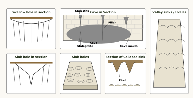
The diagram is a six-panel visual glossary of karst landforms, each panel isolating one feature so you can see how it looks in cross-section versus in plan view. The first three panels are vertical sections through the rock; the next two are block diagrams of the surface; the last is a section through a cave interior.
The top-left panel, Swallow hole in section, shows a shallow, round depression sitting in cracked, jointed rock at the surface. The point here is that a swallow hole is a modest, saucer-like pit — water simply disappears into it through the joints. Next to it, Sink hole in section shows a funnel-shaped opening that narrows downward through the same jointed rock. The contrast is deliberate: a swallow hole is shallow and broad, while a sinkhole is deeper and tapers like a funnel. The third panel, Section of Collapse sink, shows two adjacent broken-roofed sections, each labelled Cave at its base, with rubble filling the collapsed area above. This is the key teaching moment — a collapse sink forms when the roof of an underground void gives way, so the surface opening is not carved by solution but by structural failure.
The fourth panel, Sink holes as a block diagram, shows a cluster of round, funnel-shaped depressions scattered across a surface. This is the plan-view reality: sinkholes rarely appear alone; they dot the landscape in groups. The fifth panel, Valley sinks/Uvalas, shows several adjoining wide, irregular trenches. The label itself carries the lesson — when sinkholes and collapse sinks merge along their margins, the separate pits fuse into elongated, uneven valleys.
The final panel, Cave in Section, is the most detailed. It shows a cave interior with four labelled features: Stalactite, an icicle-shaped form hanging from the roof; Stalagmite, rising from the floor; Pillar, a full-height column where the two have met and joined; and Cave mouth, the outer opening where the cave meets the surface. Leader lines connect each label to its feature. This panel completes the story — the same solution process that creates surface pits also sculpts the underground world, and the pillar is the natural endpoint of stalactite and stalagmite growth. …
Small to medium-sized, round or slightly oval shallow depressions called swallow holes are the first things to appear on a limestone surface. They form simply because rainwater, made weakly acidic by carbon dioxide, dissolves the rock along cracks and weak points. These are the starting point of a whole family of landforms that develop as solution eats into the limestone.
From swallow holes come sinkholes, which are very common in limestone or karst areas. A sinkhole is an opening that is more or less circular at the top and funnel-shaped towards the bottom. Their sizes vary a great deal — in area from a few square metres up to a hectare, and in depth from less than half a metre to thirty metres or more. Not all sinkholes form the same way. Some are created purely by solution action, where the rock simply dissolves away; these are called solution sinks. Others begin as solution forms but then take a different turn — if the bottom of a sinkhole happens to form the roof of an underground void or cave, that roof can collapse, leaving a large hole that opens directly into the cave or void below. These are collapse sinks, and the term doline is sometimes used for them. Solution sinks are more common than collapse sinks.
Quite often, sinkholes get covered over by a mantle of soil and appear as shallow pools of water. This is a real danger: anyone stepping over such a pool can suddenly go down through it, much like sinking into quicksand in a desert. The surface looks harmless, but the ground beneath is hollow.
Water that enters swallow holes and sinkholes does not stay on the surface. Quite often, surface run-off simply goes down these openings and flows as underground streams, only to re-emerge at a distance downstream through a cave opening. So the surface drainage of a karst region is often lost underground, and reappears elsewhere as springs or cave exits.
When sinkholes and dolines join together — either because of slumping of material along their margins or because of the roof collapse of caves — they form long, narrow to wide trenches called valley sinks or uvalas. These are essentially enlarged, merged sinkholes that create elongated depressions on the landscape. …
Surface water percolates well where rocks are permeable, thinly bedded and highly jointed and cracked; after going down vertically to some depth, the water under the ground flows horizontally through bedding planes, joints or the materials themselves. This downward and horizontal movement of groundwater causes the rocks to erode chemically -- physical/mechanical removal by moving groundwater is insignificant. In rocks like limestones or dolomites rich in calcium carbonate, surface water and groundwater, through the chemical processes of solution and precipitation deposition, develop varieties of landforms. Any limestone or dolomitic region showing typical landforms produced by the action of groundwater through solution and deposition is called Karst topog …
Small to medium sized round to sub-rounded shallow depressions called swallow holes form on the surface of limestones through solution. A sinkhole is an opening more or less circular at the top and funnel-shaped towards the bottom, sizes varying from a few sq. m to a hectare and depth from less than half a metre to thirty metres or more. Some sinkholes form solely through solution action (solution sinks); others start as solution forms first and, if the bottom of a sinkhole forms the roof of a void or cave underground, it might collapse leaving a large hole opening into a cave or void below (collapse sinks). The term doline is sometimes used for the collapse sinks; solution sinks are more common than collapse sinks. Often, surface run-off simply goes down swallow and sink holes and flows as underground streams, re-emerging at a distance downstream through a cave opening. When sink holes and dolines join together because of slumping of materials along their margins or roof collapse of caves, long, narrow to wide trenches called valley sinks or uvalas form. Gradually, most of the surface of the limestone is eaten away by these pits and trenches, leaving it extremely irregular with a maze of …