Geography · Ch 7 — Geography as a Discipline
Branches of Geography based on Regional Approach
Branches of Geography based on Regional Approach
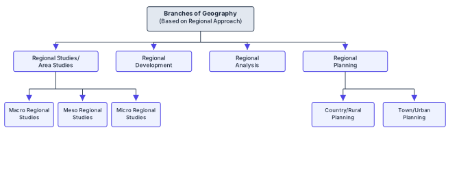
The diagram is a tree that starts from a single root box labelled Branches of Geography (Based on Regional Approach). From that root, four arrows descend into four parallel boxes: Regional Studies/Area Studies, Regional Development, Regional Analysis, and Regional Planning. These four are the core divisions of the regional approach — the idea being that when geographers study a particular part of the earth's surface, they can do so from four distinct angles: describing the region itself, examining how it changes over time, analysing its internal patterns, or planning its future.
Two of these four branches are expanded further. Regional Studies/Area Studies splits into three sub-boxes: Macro Regional Studies, Meso Regional Studies, and Micro Regional Studies. This shows that regional study operates at different scales — from large units like continents or countries, down through intermediate regions, to small local areas. The other expanded branch, Regional Planning, divides into Country/Rural Planning and Town/Urban Planning, reflecting that planning efforts differ fundamentally between rural and urban settings. …
Geography is not just about listing facts about places — it is about understanding why the earth’s surface is different from one area to another. The regional approach to geography studies these differences by dividing the earth into regions and examining how phenomena vary across them. Two geographers, Richard Hartshorne and Hettner, framed this idea clearly. Hartshorne described geography as the description and explanation of the areal differentiation of the earth’s surface. Hettner added that geography studies the differences of phenomena usually related in different parts of the earth’s surface. In simple terms, both were saying the same thing: geography asks why one part of the earth looks and behaves differently from another.
The regional approach, therefore, does not study the whole earth as one unit. Instead, it breaks the earth into regions — which could be natural, like a river basin or a mountain range, or man-made, like a country or a state — and then studies the phenomena within each region. The focus is on the uniqueness of each region and how its physical and human features combine to give it a distinct character. This is what makes the regional approach different from the systematic approach, which studies one phenomenon (like climate or soil) across the entire world.
Now, the book also tells you how technology has changed the way geographers work with the regional approach. Earlier, collecting data about different regions was slow and limited. Today, technology has transformed this process. Manual map-making has been replaced by computer cartography, which allows geographers to prepare maps quickly and accurately. Technology has also enabled scholars to handle large amounts of data — something that was simply not possible before. The internet provides extensive information about almost every part of the world, so a geographer sitting in one place can access data about distant regions with ease. Because of this, the capacity to attempt analysis has increased tremendously. …