Geography · Ch 12 — Landforms and their Evolution
Floodplains, Natural Levees and Point Bars
Floodplains, Natural Levees and Point Bars
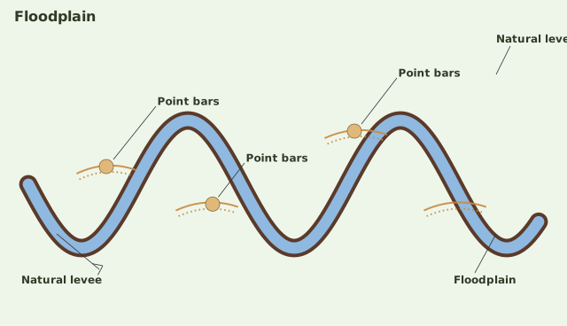
The diagram is a block view of a single meandering river channel cutting through its floodplain, drawn so you can see both the channel and the flat land on either side of it. The floodplain is the broad, level surface bordering the river, and it is labelled simply as Floodplain — it is the backdrop against which the other two landforms are shown.
Along the outer bank of the channel — the side where the water is forced against the land as the river bends — the diagram labels a Natural levee. This is drawn as a low, linear, raised ridge running parallel to the channel, sitting just above the level of the floodplain. The key point the sketch makes is positional: the levee hugs the outside of the bend, where the river's energy is highest and where coarser material gets dumped first when floodwaters spill over the bank.
On the inside (convex) bank of each meander bend, the diagram labels Point bars, with an arrow pointing to them. These are drawn as crescent-shaped deposits built up along the inner curve of the channel, where the water slows and drops its load. The arrow draws your eye to the shape — a curved, bank-attached accumulation that mirrors the bend of the river. …
A river doesn’t only carve — it also builds. Just as erosion carves out a valley, deposition builds up a floodplain, and this floodplain is one of the major landforms created by river deposition. The whole process hinges on one simple idea: when a stream’s channel breaks onto a gentler slope, its speed drops, and the largest materials settle out first. That’s why the finer stuff — sand, silt and clay — is carried by the relatively slow-moving waters of gentler channels, which are typically found in the plains. These fine materials get deposited over the river bed, and when the waters spill over the banks during flooding, they get deposited above the bed as well.
This gives us two distinct parts of a floodplain. The river bed itself, made of river deposits, is the active floodplain — it’s the part that’s under water in normal flow. The floodplain above the bank is the inactive floodplain, because it only gets water when the river overflows. The inactive floodplain above the banks contains two types of deposits: flood deposits and channel deposits.
Here’s where it gets interesting. In the plains, channels don’t stay put. They shift laterally and occasionally change their courses altogether, leaving behind cut-off courses that gradually fill up. These abandoned or cut-off channels build up areas on the floodplain that contain coarse deposits — because when a channel is cut off, the heavier material it was carrying settles right there. In contrast, the flood deposits from spilled waters carry relatively finer materials like silt and clay, since the water that overflows the bank is moving slowly and can only hold fine particles. When a floodplain forms in a delta, it’s given a special name: the delta plains.
Two more landforms are closely tied to floodplains, and the book treats them together because they’re often found side by side.
Natural levees are found along the banks of large rivers. They are low, linear and parallel ridges of coarse deposits running along the banks, and quite often they get cut into individual mounds. Think of them as the river’s own raised embankments, built up over time as floodwaters drop their heaviest load right at the edge of the channel.
Point bars, also known as meander bars, are found on the concave side of meanders of large rivers. They are sediments deposited in a linear fashion by flowing waters along the bank. Unlike levees, they are almost uniform in profile and in width, and they contain mixed sizes of sediments.
| Feature | Natural Levees | Point Bars |
|---|---|---|
| Location | Along the banks of large rivers | On the concave side of meanders of large rivers |
| Shape | Low, linear, parallel ridges; often cut into individual mounds | Linear deposits along the bank |
| Sediment | Coarse deposits | Mixed sizes of sediments |
Deposition develops a floodplain just as erosion makes valleys. A river bed made of river deposits is the active floodplain; the floodplain above the bank is the inactive floodplain, containing flood deposits (finer silt and clay left by spilled waters) and channel deposits (coarser material left in abandoned cut-off channels). Natural levees are low, linear and parallel ridges of coarse deposits found along the banks of large rivers, quite often cut into individual mounds. Point bars, also known as meander bars, are found on the convex (inside) bank of meanders of large rivers -- sediments deposited in a linear fashion by flowing waters along the bank, almost u …