Geography · Ch 12 — Landforms and their Evolution
Meanders
Meanders
The satellite scene shows the Burhi Gandak river as it winds through the flat alluvial plains near Muzaffarpur in Bihar. The river does not follow a straight course; instead, it traces a series of pronounced, looping bends that snake across the landscape. The image is a top-down view, so the full sinuous path of the channel is visible at once, with the water appearing as a bright, continuous ribbon against the darker, cultivated land around it.
What makes the scene instructive is not just the meandering channel itself, but the evidence of the river’s past behaviour scattered alongside it. Scattered near the active channel are several crescent-shaped water bodies, completely detached from the main river. These are oxbow lakes — the abandoned remnants of former meander loops that were cut off when the river broke through the narrow neck of a bend. Each crescent mirrors the curvature of the loop that once existed there, and their presence in clusters tells you that the river has repeatedly shifted its course over time, leaving these cut-offs behind as it migrated across the floodplain. …
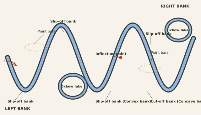
The diagram is a plan-view sketch of a river flowing between two banks, labelled RIGHT BANK and LEFT BANK. The channel does not run straight; it bends into a series of loops, each one a meander. The key teaching device is the contrast between the two sides of each bend, shown with different line styles and labels.
On the inside of each curve — the convex bank — a dashed line traces the growth of point bars. The dashes show that this bank is not a fixed edge but a zone of active deposition, building outward as sediment is dropped. This is the slip-off bank, labelled directly, and it is drawn with a long, gentle profile. On the outside of the same curve, the concave bank is drawn with a solid line and labelled the cut-off bank. This is the side where the river undercuts its own bank, producing a steep scarp. So each loop carries a paired message: deposition builds one side while erosion eats the other.
Two of the loops have been pinched off completely. Their necks have been eroded through at the points where the channel nearly doubled back on itself, and the abandoned bends now sit detached from the main flow as oxbow lakes. These are drawn as isolated, crescent-shaped water bodies beside the active channel, showing the end stage of meander evolution.
One loop carries an extra marker: a small circle with an arrow at the inflection point. This is the location where the curvature of the channel reverses — the bend changes from curving one way to curving the other. The arrow indicates the direction of flow or the sense of curvature change. The inflection point matters because it is the site where erosion can eventually breach the meander neck, turning a growing loop into a cut-off oxbow lake. …
Rivers flowing across large flood plains and delta plains rarely follow a straight course. Instead, they develop a series of smooth, looping bends called meanders. These loops are not random accidents — they form because of a continuous, self-reinforcing interaction between the river's flow and its banks.
The process begins modestly. A small curvature appears in the bank, and once it exists, it tends to deepen. The reason lies in how the river's energy is distributed. On the inside of the curve, the water slows down and drops its sediment load, building up the bank through deposition. On the outside of the curve, the water moves faster and with more force, eroding and undercutting the bank. This combination — deposition on one side, erosion on the other — makes the bend grow steadily more pronounced.
The two banks of a meander are therefore very different in character. The concave bank, on the outside of the curve, is the one being eroded and undercut. It is known as the cut-off bank, and it appears as a steep scarp or cliff. The convex bank, on the inside of the curve, is the one receiving deposits. It presents a long, gentle, sloping profile. So a single meander shows both a sharp, steep face and a smooth, gradual slope, depending on which side you look at.
Meanders require both deposition and erosion to grow. If there is no deposition on the inside and no erosion or undercutting on the outside, the tendency to meander is reduced. In large rivers, however, active deposition along the convex bank and undercutting along the concave bank are the normal, ongoing processes. …
In large flood and delta plains, rivers rarely flow in straight courses; loop-like channel patterns called meanders develop over flood and delta plains. A meander is not a landform but only a type of channel pattern, arising because of (i) the propensity of water flowing over very gentle gradients to work laterally on the banks; (ii) the unconsolidated nature of alluvial deposits making up the banks, with many irregularities water can exert lateral pressure on; and (iii) coriolis force acting on the fluid water, deflecting it like it deflects the wind. Slight irregularities along the banks slowly get transformed into a small curvature; the curvature deepens due to deposition on the inside of the curve and erosion along the bank on the outside. The concave bank is known as the cut-off bank, showing up as a steep scarp; the convex bank presents a long, gentle profile …