Geography · Ch 12 — Landforms and their Evolution
Glacial Valleys/Troughs
Glacial Valleys/Troughs
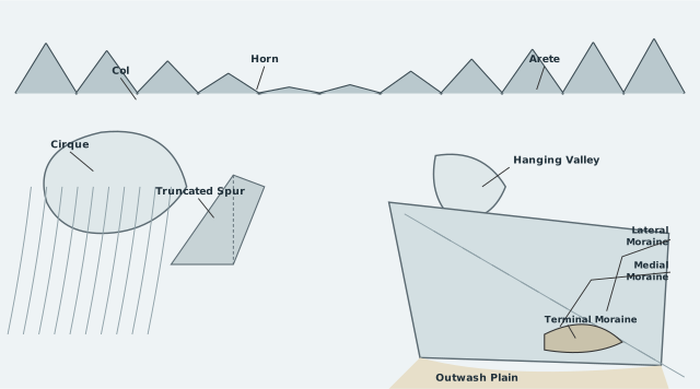
The diagram is a single panoramic cross-section of a glaciated mountain range, drawn as a labelled landscape rather than a technical map. It reads left to right along the skyline, then drops down into the valley floor, so the eye moves from the highest erosional features to the lowest depositional ones. This layout is the key teaching point: the diagram is arranged as a journey from the zone of glacial erosion (the peaks) down to the zone of glacial deposition (the plains).
At the top, three erosional landforms sit along the ridgeline. A Col is shown as a low saddle or gap between two peaks — the remnant of a cirque that has been breached from both sides. A Horn rises as a sharp, high pointed peak, formed where several cirques have eaten into a mountain from different directions, leaving only a pyramidal core. An Arete appears as a narrow, serrated ridge, the knife-edge left between two parallel glacial valleys. These three are grouped together because they all result from the same process: headward erosion by ice plucking and abrasion, which carves away the mountain from multiple sides.
Below the skyline, the diagram labels a Cirque as a deep, bowl-shaped basin at the head of a glacial valley. This is the birthplace of the glacier, where snow accumulates and ice rotates, scooping out a steep-walled amphitheatre. Just beside it, a Truncated Spur shows a ridge whose end has been sliced off flat, at the mouth of a tributary valley. The glacier, moving down the main valley, has simply cut across the spurs that once projected into it, shearing them off to create a clean, cliff-like face.
The right side of the diagram is dominated by a large glacial trough descending toward the viewer's right. A Hanging Valley is labelled as a smaller tributary valley whose floor sits well above the main trough floor. This is the classic signature of glacial erosion: the main glacier, being larger and heavier, deepened its valley far more than the smaller tributary glacier could, so when the ice melted, the tributary was left suspended above the main valley, often ending in a waterfall. Along the glacier itself, the diagram shows two types of moraine: Lateral Moraine as long ridges of debris running along the sides of the glacier, and Medial Moraine as a ridge running down the centre. The medial moraine forms where two lateral moraines merge when tributary glaciers join the main one — a detail the diagram implies by showing the tributary valley feeding into the main trough.
At the glacier's end, the depositional forms take over. A Terminal Moraine is drawn as a curved ridge of debris marking the furthest extent of the glacier's advance — the dump of material pushed ahead of the ice front. Beyond it, an Outwash Plain spreads out as a broad, flat area of glacio-fluvial deposits. The diagram's placement of these two is deliberate: the terminal moraine is the boundary between ice-deposited till (unsorted, angular) and the meltwater-deposited outwash (stratified, rounded), which the textbook text describes as the fundamental difference between till and outwash deposits. …
A glacier moving through a river valley reshapes it completely. Where a river cuts a narrow, V-shaped notch, a glacier carves out a wide, deep trough. The result is a landscape that looks nothing like the work of flowing water, and the features that fill these valleys — debris, lakes, hanging tributaries — all carry the signature of ice.
The shape of a glacial valley
Glaciated valleys are trough-like and U-shaped. Their floors are broad and flat, and their sides are steep yet relatively smooth. This is the classic cross-profile of glacial erosion: the ice grinds the valley bottom wide and scrapes the walls clean, unlike the sharp, angular V of a river-cut valley.
The valley floor is rarely bare rock. It may be littered with debris, or the debris may be organised into mounds called moraines, which often give the valley a swampy appearance. Water collects in the hollows between these mounds, turning the floor marshy. Lakes also form inside the valley — some gouged directly out of the rocky floor by the ice itself, others created when debris dams a valley and ponds up water behind it.
Hanging valleys and truncated spurs
On one or both sides of the main glacial valley, you may find tributary valleys sitting at a higher elevation. These are hanging valleys. They exist because the main glacier was far more powerful and cut its floor much deeper than the smaller tributary glaciers could. When the ice melts away, the tributary valley is left suspended above the main trough, often ending in a cliff over which a stream may plunge as a waterfall.
Where these hanging valleys open into the main glacial valley, the faces of the divides or spurs between them are frequently truncated — sliced off by the ice. This cutting produces a striking shape: the spur ends look like triangular facets, flat-faced and steep, as if a knife had sheared the ridge ends clean.
Fjords
When a very deep glacial trough is filled with sea water and forms part of a shoreline, it is called a fjord or fiord. These occur in high latitudes, where glaciers once reached the coast and carved valleys well below sea level. After the ice retreated, the sea flooded the troughs, creating long, narrow, steep-sided inlets.
Glacial valleys versus river valleys
The differences are fundamental and easy to summarise:
| Feature | Glacial valley | River valley |
|---|---|---|
| Cross-profile | U-shaped, broad floor, steep smooth sides | V-shaped, narrow floor, sloping sides |
| Course | Generally straight, follows the ice's path | Winding, meandering |
| Tributaries | Hanging valleys at higher elevation | Join at the same level |
| Spurs | Truncated, forming triangular facets | Rounded or interlocking |
Depositional landforms
Melting glaciers drop their load in two distinct ways, producing two very different kinds of deposit.
Glacial till is the unassorted coarse and fine debris dropped directly by the melting ice. It is unsorted — boulders, gravel, sand and clay all dumped together with no layering. Most of the rock fragments in till are angular to sub-angular, because they were carried within the ice and never tumbled by water. …
Glaciated valleys are trough-like and U-shaped, with broad floors and relatively smooth, steep sides. The valleys may contain littered debris or debris shaped as moraines with a swampy appearance. There may be lakes gouged out of the rocky floor or formed by debris within the valleys. There can be hanging valleys at an elevation on one or both sides of the main glacial valley -- the faces of the divides or spurs of such hanging valleys, opening into the main glacial valley, are quite often truncated to give them an appearance like triangular facets (truncated spurs). Very deep glacial t …