Geography · Ch 12 — Landforms and their Evolution
Moraines
Moraines
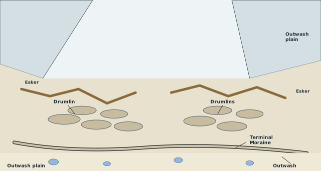
The diagram is a wide, panoramic reconstruction of a glacial valley long after the ice has mostly vanished. Two tributary valleys converge from the upper left and right, meeting in a broad, open lowland that slopes gently away. The scene is drawn from an elevated vantage point so you can see the whole landscape at once — the kind of view a geographer would use to trace how a glacier reshaped the ground beneath it.
The lower ground is the real focus. Scattered across it are drumlins: smooth, elongated oval mounds, all aligned with their long axes pointing in the same direction — the direction the former ice moved. Their parallel orientation is the key teaching point: drumlins are streamlined by ice flow, so they act like fossil compass needles for reconstructing the glacier's path. Winding across the same plain are eskers — sinuous, snake-like ridges that mark where meltwater once ran in tunnels beneath the ice. As the glacier thinned and retreated, the sediment carried by those subglacial streams was dumped in long, winding ridges that now stand above the surrounding ground.
At the far edge of the plain, a curved arc of debris is labelled terminal moraine — the ridge of till dumped at the glacier's furthest advance. Beyond it spreads the outwash plain, a fan of gravel and sand washed out from the melting ice front. Dotted across this plain are small, roughly circular depressions: kettle lakes, formed when blocks of ice buried in the outwash melted and left hollows behind. An arrow labelled outwash points away from the moraine, showing the direction in which meltwater carried sediment outward from the ice. …
Moraines are long ridges built up from deposits of glacial till — the unsorted rock debris a glacier carries and drops. They are among the most visible depositional landforms left behind by glaciers, and their shape and position tell you a great deal about how the glacier moved and where it once stood.
The most straightforward type is the terminal moraine, a long ridge of debris dumped at the end, or toe, of the glacier. This marks the farthest point the ice reached; when the glacier melts back, that ridge stays behind as a record of its maximum advance.
Along the sides of a glacial valley, running parallel to the direction of ice flow, you find lateral moraines. These form on either flank of the glacier. A striking thing happens where a lateral moraine curves around and meets a terminal moraine — together they enclose the valley in a horse-shoe shaped ridge. A single glacial valley can carry many lateral moraines on each side, not just one. Their origin is only partly glacial: they owe much to glacio-fluvial waters, the meltwater streams that push and pile material up against the sides of the glacier.
When a valley glacier retreats rapidly, it often leaves behind an irregular, patchy sheet of till spread over the valley floor. This deposit varies greatly in both thickness and surface topography, and it is called a ground moraine. Unlike the sharp, well-defined ridges of terminal and lateral moraines, the ground moraine is a rough, uneven blanket of debris. …
Moraines are long ridges of deposits of glacial till (the unassorted coarse and fine debris dropped by melting glaciers; most rock fragments in till are angular to sub-angular). Terminal moraines are long ridges of debris deposited at the end (toe) of glaciers. Lateral moraines form along the sides parallel to the glacial valleys, and may join a terminal moraine to form a horse-shoe shaped ridge; there can be many lateral moraines on either side in a glacial valley, owing their origin partly or fully to glacio-fluvial waters pushing up materials to the sides of glaciers. Many valley glaciers retreating rapidly leave an irregular sheet of till over their valley floors, varying greatly in thickness and surface topography -- such deposits are called ground moraines. The moraine in the centre of the glacial valley, flanked by lateral moraines, i …