Geography · Ch 14 — Solar Radiation, Heat Balance and Temperature
Variation in the Net Heat Budget at the Earth's Surface
Variation in the Net Heat Budget at the Earth's Surface
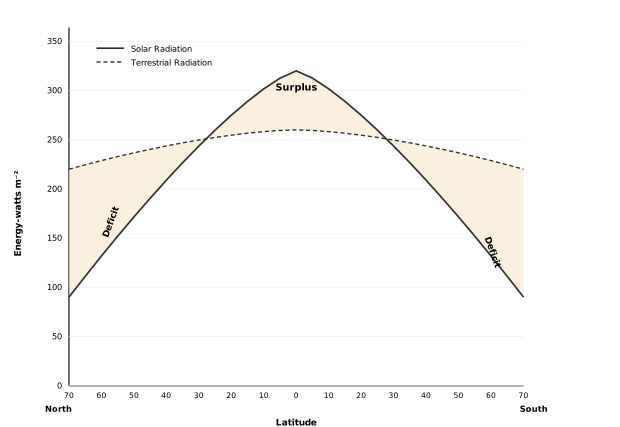
The diagram is a simple line graph, and its whole point is to show that the Earth does not gain or lose heat uniformly with latitude. The vertical axis measures energy in watts per square metre, running from 0 up to 350. The horizontal axis is latitude, stretching from 70° North on the left, through the Equator at 0°, to 70° South on the right. Two curves are drawn across this frame. A solid line represents incoming solar radiation; a dashed line represents outgoing terrestrial radiation. Both curves rise from the poles and peak near the Equator, then fall symmetrically toward the opposite pole.
The critical feature is where the two lines cross. They intersect at roughly 40° North and 40° South. Between these two crossing points — the belt from 40°N to 40°S — the solid solar radiation curve sits above the dashed terrestrial curve. The vertical gap between them is shaded and labelled Surplus. Beyond each crossing point, moving toward the poles, the dashed terrestrial curve rises above the solid solar curve, and that gap is shaded and labelled Deficit on both the northern and southern sides. …
The Big Picture First
The Earth does not receive the same amount of solar energy everywhere. Because the planet is a sphere, the tropics get far more incoming radiation than the poles. If nothing corrected this imbalance, the tropics would keep getting hotter and hotter while the poles would freeze solid. Neither happens. The reason is that the atmosphere and oceans constantly move heat from where there is a surplus to where there is a deficit. This section explains that redistribution, and then goes on to list the factors that control the temperature of any particular place.
Surplus and Deficit Zones
There are clear variations in the amount of radiation received at the Earth's surface. Some parts of the Earth have a surplus radiation balance — they receive more energy than they lose. Other parts have a deficit — they lose more energy than they receive.
The latitudinal variation in the net radiation balance of the Earth–atmosphere system shows a clear pattern:
- There is a surplus of net radiation balance between 40 degrees North and 40 degrees South.
- The regions near the poles have a deficit.
This surplus heat energy from the tropics is redistributed polewards. As a result of this transfer, two things are prevented:
- The tropics do not get progressively heated up due to the accumulation of excess heat.
- The high latitudes do not get permanently frozen due to an excess deficit.
So the poleward transfer of heat is what keeps the planet's temperature system in balance.
Factors Controlling the Temperature of a Place
The section then moves from the global picture to the local one — what determines the temperature of a specific place. Five factors are listed.
1. The Latitude
The temperature of a place depends on the insolation it receives. Since insolation varies according to latitude, temperature also varies accordingly. Places near the equator receive more direct and concentrated sunlight, so they are warmer; places near the poles receive slanting, spread-out sunlight, so they are colder.
2. The Altitude
The atmosphere is indirectly heated by terrestrial radiation coming from below — the ground absorbs solar energy and then radiates heat upward. Therefore:
- Places near sea level record higher temperatures.
- Places at higher elevations record lower temperatures.
In other words, temperature generally decreases with increasing height. The rate of this decrease is called the normal lapse rate, and it is 6.5°C per 1,000 metres.
3. Distance from the Sea
The location of a place with respect to the sea matters a great deal. The key difference is in how land and water respond to heat:
- The sea gets heated slowly and loses heat slowly.
- Land heats up quickly and cools down quickly.
So the variation in temperature over the sea is less than over land. Places situated near the sea come under the moderating influence of sea and land breezes, which moderate the temperature — keeping it cooler in summer and warmer in winter than inland places at the same latitude.
4. Air-Mass and Ocean Currents
Just like land and sea breezes, the passage of air masses affects temperature:
- Places under the influence of warm air-masses experience higher temperatures.
- Places under the influence of cold air-masses experience low temperatures.
The same logic applies to ocean currents:
- Coastal places where warm ocean currents flow record higher temperatures.
- Coastal places where cold currents flow record lower temperatures.
5. Local Aspects
The book lists local aspects as a fifth factor, though it does not elaborate on them in this section. These refer to site-specific conditions — such as slope direction, vegetation, or urbanisation — that can modify the temperature of a small area.
The Complete List at a Glance
| Factor | Effect on Temperature |
|---|---|
| Latitude | Higher latitude → lower temperature (insolation decreases) |
| Altitude | Higher elevation → lower temperature (normal lapse rate 6.5°C per 1,000 m) |
There are variations in the amount of radiation received at the earth's surface -- some parts of the earth have a surplus radiation balance while other parts have a deficit. The latitudinal variation in the net radiation balance of the earth-atmosphere system shows a surplus of net radiation balance between 40 degrees north and south, while regions near the poles have a deficit. The surplus heat energy from the tropics is redistributed pole-wards, and as a result, the tropics do not get progressively heated up due to accumu …