Geography · Ch 18 — Water (Oceans)
Continental Slope
Continental Slope
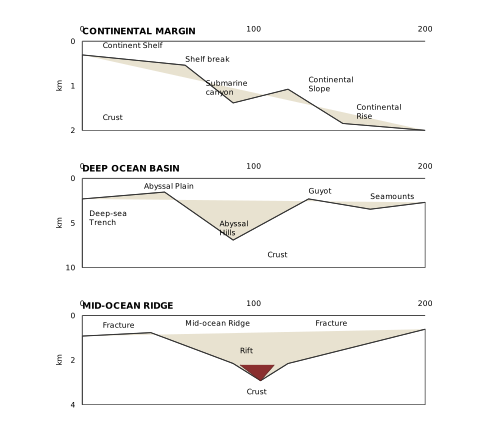
The diagram is built as three separate block diagrams, each showing a vertical slice of the seafloor from the coast out to the deep ocean. Every panel carries a depth scale in kilometres on the left and a horizontal distance scale in kilometres along the top, so you can read off both how deep a feature sits and how far from shore it lies. The three panels are not one continuous cross-section; they are three distinct zones of the ocean floor, each drawn to its own vertical scale.
Panel 1 — Continental Margin. The depth axis runs only from 0 to 2 km, and the horizontal axis from 0 to 200 km. This panel shows the transition from land to deep sea. Starting at the left, the Continental Shelf is a shallow, gently sloping platform. It ends abruptly at the Shelf break, where the seafloor begins to drop steeply. Cutting into the shelf and slope is a Submarine canyon, a V-shaped valley carved into the margin. Below the break, the Continental Slope descends steeply, and at its base the gradient flattens into the Continental Rise, a wedge of sediment that grades into the deep ocean floor. The Crust is shown beneath the entire margin, forming the solid foundation of these features. The key teaching point: the continental margin is the submerged edge of the continent, and the slope marks the true boundary of the continental landmass.
Panel 2 — Deep Ocean Basin. Here the depth axis stretches to 10 km, because this panel contains the deepest parts of the ocean. The horizontal scale is again 0–200 km. The dominant feature is the Abyssal Plain, a vast, flat expanse of the deep seafloor. Rising from it are Abyssal Hills, low rounded elevations, and taller volcanic peaks called Seamounts. One seamount has a flat, truncated top — that is a Guyot, a seamount whose summit was eroded flat when it was at the surface and has since subsided. The most dramatic feature is the Deep-sea Trench, a narrow, extremely deep depression that plunges far below the abyssal plain, reaching the bottom of the 10 km scale. The Crust underlies the whole basin. This panel teaches that the deep ocean floor is not uniformly flat — it has plains, hills, volcanic mountains, and the deepest chasms on Earth.
Panel 3 — Mid-Ocean Ridge. The depth axis runs 0–4 km, and the horizontal axis 0–200 km. The central feature is the Mid-ocean Ridge, a broad, elevated swell of the seafloor. Along its crest runs a Rift, a central valley where the ridge is being pulled apart. The ridge is cut by Fracture zones — two are labelled — which are faults that offset the ridge line horizontally. The Crust is shown beneath the ridge. This panel illustrates that the mid-ocean ridge is a site of seafloor spreading: new crust forms at the rift, and the fracture zones accommodate the differential movement of ridge segments. …
The continental slope is the steep, transitional zone that links the shallow continental shelf with the deep ocean basins. It marks the true edge of the continents — beyond it lies the deep ocean floor.
The slope begins at the point where the bottom of the continental shelf drops off sharply. This is not a gradual incline but a distinct, steep descent into the depths. The gradient of this slope region varies between 2° and 5°, which is noticeably steeper than the nearly flat shelf above it.
The depth of the slope region ranges from about 200 metres to 3,000 metres. This wide range reflects the fact that the slope descends from the relatively shallow shelf edge down toward the much deeper ocean basins. The lower boundary of the slope, where it meets the basin floor, indicates the end of the continents themselves — beyond this line, the crust is oceanic rather than continental. …
The continental slope connects the continental shelf and the ocean basins. It begins where the bottom of the continental shelf sharply drops off into a steep slope. The gradient of the slope region varies between 2-5 degrees. The depth of the slope region varies between 200 and 3,000 m. The slope boundary indicates the end of the co …