Geography · Ch 7 — Transport and Communication
The Panama Canal
The Panama Canal
The Panama Canal connects the Atlantic Ocean (east) to the Pacific Ocean (west). It was built across the Isthmus of Panama, the narrow strip of land that separates the two oceans, running between the cities of Panama City and Colon.
The United States government constructed the canal. As part of the project, it purchased a strip of land 8 km wide on either side of the canal route and designated it the Canal Zone.
The canal is about 72 km long. For a stretch of 12 km, it required very deep cutting through the rock of the isthmus. Because the land rises above sea level, the canal uses a six-lock system. Ships are raised and lowered through these locks by 26 metres (up and down) before they can enter the Gulf of Panama on the Pacific side.
The Panama Canal shortens the sea distance between New York and San Francisco by 13,000 km.
Beyond that single figure, the canal also reduces the sea route between:
- Western Europe and the west coast of the U.S.A. …
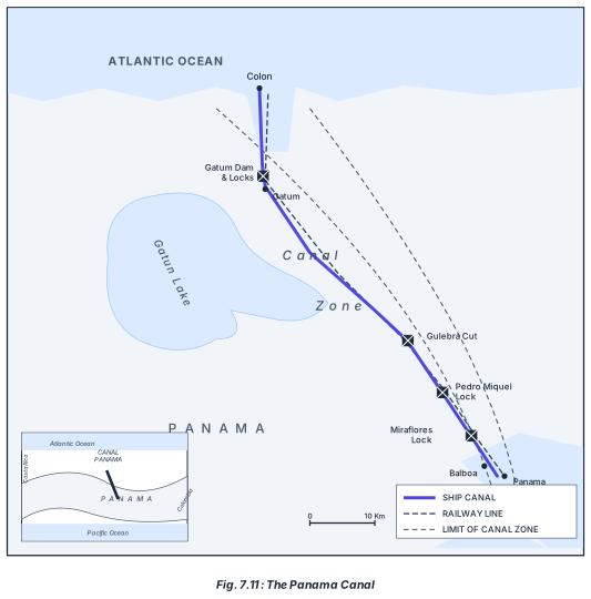
The diagram is a schematic map of the Panama Canal, drawn to show the canal's route across the Isthmus of Panama. It is not a detailed topographic map but a simplified, labelled plan that highlights the key engineering features and the sequence of locks and lakes a ship passes through.
At the top (north) of the main map is Colon, a port city on the Atlantic Ocean. From Colon, the canal enters the Gatun Locks and passes the Gatun Dam. These locks raise ships up to Gatun Lake, an artificial freshwater lake that forms the central, high-level section of the canal. The canal then cuts through the Gaillard Cut (also labelled as the Gulebra Cut), a deep, narrow channel carved through the continental divide. After the cut, ships encounter the Pedro Miguel Lock, which lowers them to a smaller lake, and then the Miraflores Locks, which lower them further to sea level. The canal ends at Balboa, a port on the Pacific Ocean, near Panama City. The entire route runs roughly north-west to south-east, not east–west as one might assume.
A legend on the diagram uses three symbols: a solid line for the SHIP CANAL itself, a dashed line for the RAILWAY LINE (the Panama Canal Railway, which runs parallel to the canal), and a dotted boundary for the LIMIT OF CANAL ZONE — the 8 km wide strip of land on either side of the canal that was controlled by the United States. A scale bar shows 0 to 10 km, giving a sense of the canal's total length of about 72 km.
An inset map in a corner shows a small locator map of Central America, covering Costa Rica, Panama, and Colombia. A marker on this inset indicates the position of the Panama Canal across the isthmus, helping the student see its geographic context between the Caribbean Sea (Atlantic) and the Pacific Ocean.
The diagram directly illustrates the textbook's description: the six-lock system (Gatun, Pedro Miguel, and Miraflores — each with two chambers, making six total), the 12 km of deep cutting through the Gaillard Cut, and the 26 m elevation change that ships navigate. The railway line shown was historically crucial during the canal's construction and remains important for cargo transport today. …