Geography · Ch 7 — Transport and Communication
The Suez Canal
The Suez Canal
The Suez Canal is a man-made sea-level waterway in Egypt, built to connect the Mediterranean Sea with the Red Sea. It was completed in 1869 and fundamentally changed global maritime trade by providing a direct route between Europe and Asia.
The canal runs from Port Said in the north to Port Suez in the south. It links the Mediterranean Sea with the Red Sea, giving Europe a new gateway to the Indian Ocean. This drastically reduces the sea-route distance between Liverpool and Colombo compared to the older route around the Cape of Good Hope.
Key physical features of the canal:
- It is a sea-level canal, meaning it has no locks — ships pass through at the same water level throughout.
- Its length is about 160 kilometres, and its depth ranges from 11 to 15 metres.
- A railway line follows the canal to Suez, and from Ismailia a branch line connects to Cairo.
- A navigable fresh-water canal from the River Nile also joins the Suez Canal at Ismailia, supplying fresh water to Port Said and Suez.
Traffic and tolls:
- Around 100 ships travel through the canal daily. …
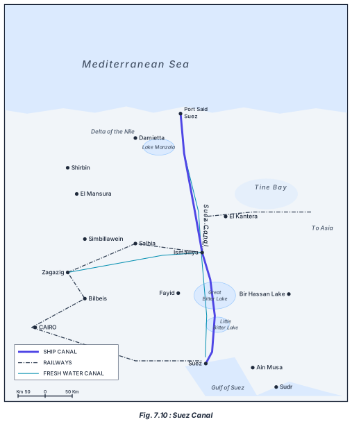
The diagram is a labelled map of the Suez Canal region in Egypt, showing the canal’s full route and its relationship to the surrounding geography. The canal itself runs roughly north–south, connecting the Mediterranean Sea at Port Said to the Gulf of Suez at Port Suez. Along its path, the map marks several key water bodies the canal passes through: Lake Manzala near the northern end, then El Kantera, Ismailia (where a branch railway to Cairo begins), the Great Bitter Lake, the Little Bitter Lake, and finally Bir Hassan Lake to the east of the southern section.
To the west of the canal lies the Nile delta, with several towns and cities labelled: Damietta, Shirbin, El Mansura, Simbillawein, Salhia, Zagazig, Bilbeis, Fayid, and Cairo. The map also shows a fresh-water canal that branches off from the Nile and joins the Suez Canal at Ismailia, supplying fresh water to Port Said and Suez. A railway line runs parallel to the ship canal all the way to Suez, and from Ismailia a branch line goes to Cairo.
The legend uses three symbols: one for the SHIP CANAL (the main Suez Canal), one for RAILWAYS, and one for the FRESH WATER CANAL. A scale bar reads “Km 50–0–50 Km,” giving a sense of distance. To the east of the canal, the map labels “Tine Bay” and “To Asia,” indicating the direction toward the Asian continent. …