Geography · Ch 15 — Atmospheric Circulation and Weather Systems
Tropical Cyclones
Tropical Cyclones
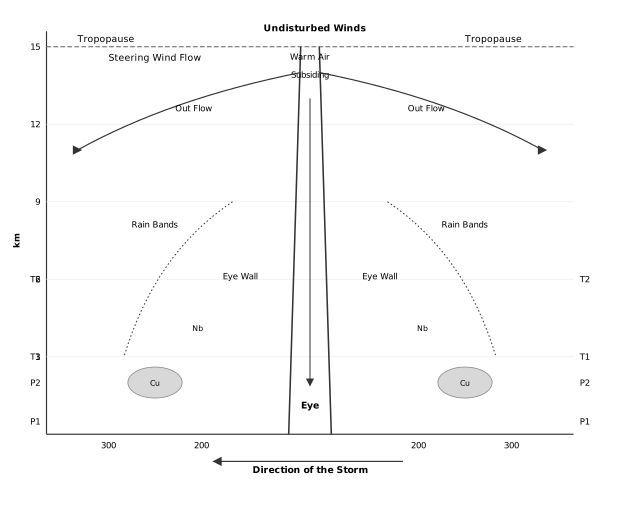
The diagram is a vertical cross-section, slicing a mature tropical cyclone from top to bottom so you can see its internal anatomy. The vertical axis on the left is height, marked in kilometres at 3, 6, 9, 12 and 15, climbing up to the tropopause. The horizontal axis is distance, marked in kilometres at 300 and 200 on each side of the central point, giving you a sense of the storm's enormous horizontal scale compared to its vertical reach.
At the very centre sits the Eye — a narrow, vertical column rising through the entire storm. This is the region of calm, and the diagram shows Subsiding Warm Air descending into it from above. Flanking the eye on both sides is the Eye Wall, the ring where the storm's most violent activity is concentrated. The eye wall is where air spirals upward with maximum force, and the diagram places it as the most intense vertical column of rising motion in the whole system.
Above the eye and eye wall, at the top of the storm beneath the Tropopause, curved Out Flow arrows spread outward in both directions. This is the upper-level divergence that ventilates the storm — air that has risen through the eye wall is thrown out horizontally at the top. Above this outflow layer, the diagram labels Undisturbed Winds and Steering Wind Flow, showing that the storm's upper circulation is embedded in, and carried along by, the larger-scale winds of the upper atmosphere.
At lower levels on both sides of the eye, the diagram shows Rain Bands radiating outward. These bands carry cloud symbols for cumulonimbus (Cu) and nimbostratus (Nb), the towering and layered clouds that produce the torrential rain. On the outer edges of the cross-section, pressure levels P1/P2 and temperature levels T1/T2 are marked, indicating the environmental gradients of pressure and temperature that the storm disturbs. Finally, a Direction of the Storm arrow points left at the bottom, showing the whole system translating horizontally as it moves across the ocean. …
Tropical cyclones are among the most violent and destructive weather systems on Earth. They are born over warm tropical oceans, travel toward coasts, and unleash their fury through ferocious winds, torrential rain, and storm surges that flood low-lying coastal land. Understanding how they form, what feeds them, and why they die is central to grasping the larger story of atmospheric circulation.
These storms go by different names in different parts of the world. In the Indian Ocean they are called cyclones; in the Atlantic they are hurricanes; in the Western Pacific and South China Sea they are typhoons; and in Western Australia they are known as willy-willies. Whatever the name, the physics is the same.
Favourable Conditions for Formation
A tropical cyclone does not appear out of nowhere. It needs a specific set of conditions to originate and intensify over warm tropical seas:
- Large sea surface with temperature higher than 27°C — this warm water is the storm's fuel tank.
- Presence of the Coriolis force — this gives the system its spin; without it, the storm cannot organise into a rotating circulation.
- Small variations in vertical wind speed — strong wind shear would tear the developing storm apart, so the atmosphere above must be relatively calm.
- A pre-existing weak low-pressure area or low-level cyclonic circulation — the cyclone builds upon an already disturbed region.
- Upper divergence above the sea-level system — air spreading out at the top helps draw air upward from below, sustaining the low pressure at the surface.
The Engine: Condensation and Moisture
The energy that intensifies the storm comes from the condensation process inside towering cumulonimbus clouds that surround the centre of the storm. As warm, moist air rises, water vapour condenses, releasing latent heat. This heat warms the air further, making it rise even more vigorously, which in turn draws in more moist air from the sea surface. As long as the storm has a continuous supply of moisture from the ocean, it strengthens.
The moment the cyclone moves over land, that moisture supply is cut off. Deprived of its fuel, the storm weakens and eventually dissipates. The point where the cyclone crosses the coast is called the landfall of the cyclone.
Recurving and Destructiveness
Cyclones that cross the 20°N latitude generally recurve — that is, they change direction, often swinging toward the northeast. These recurved storms tend to be more destructive than those that do not recurve.
Anatomy of a Mature Tropical Cyclone
A mature tropical cyclone has a well-defined vertical and horizontal structure.
At the centre lies the eye — a region of calm with subsiding (sinking) air. The diameter of the circulating system around the eye can vary between 150 and 250 km. Surrounding the eye is the eye wall, where air spirals violently upward to great heights, reaching the tropopause. This is where the wind reaches its maximum velocity, sometimes as high as 250 km per hour, and where torrential rain occurs.
From the eye wall, rain bands may radiate outward, and trains of cumulus and cumulonimbus clouds drift into the outer regions of the storm.
| Feature | Description |
|---|---|
| Eye | Central region of calm, subsiding air |
| Eye wall | Ring of strong spiralling ascent; maximum wind speed (up to 250 km/h); torrential rain |
Tropical cyclones are violent storms that originate over oceans in tropical areas and move over to the coastal areas, bringing about large scale destruction caused by violent winds, very heavy rainfall and storm surges. They are known as Cyclones in the Indian Ocean, Hurricanes in the Atlantic, Typhoons in the Western Pacific and South China Sea, and Willy-willies in Western Australia.
Tropical cyclones originate and intensify over warm tropical oceans. The conditions favourable for the formation and intensification of tropical storms are: (i) Large sea surface with temperature higher than 27 degree C; (ii) Presence of the Coriolis force; (iii) Small variations in the vertical wind speed; (iv) A pre-existing weak-low-pressure area or low-level-cyclonic circulation; (v) Upper divergence above the sea level system. The energy that intensifies the storm comes from the condensation process in the towering cumulonimbus clouds surrounding the centre of the storm -- with continuous supply of moisture from the sea, the storm is further strengthened. On reaching the land the moisture supply is cut off and the storm dissipates. The place where a tropical cyclone crosses the coast is called the landfall of the cyclone. Cyclones which cross 20 degree N latitude generally recurve and are more destructive. …