Geography · Ch 15 — Atmospheric Circulation and Weather Systems
General Circulation of the Atmosphere
General Circulation of the Atmosphere
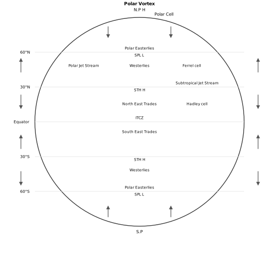
The diagram is a vertical cross-section of the atmosphere, sliced from the North Pole on the left to the South Pole on the right. The Equator sits in the middle, and the whole picture is divided into three stacked circulation loops in each hemisphere — six cells in total, arranged symmetrically about the Equator. Each cell is drawn as a closed oval of arrows, showing air rising, moving horizontally aloft, sinking, and returning along the surface.
Start at the poles. At each pole the label N.P and S.P marks the location, and here the diagram shows cold, dense air sinking — this is the high-pressure zone marked H. This sinking air spreads outward along the surface toward 60° latitude, and these surface winds are labelled Polar Easterlies. At 60° North and South the diagram marks a sub-polar low with the label SPL, L — a belt of low pressure where the cold polar air meets warmer air from the south. This entire loop, from pole to 60°, is the Polar Cell (sometimes called the Polar Vortex in the caption's description).
Between 60° and 30° lies the Ferrel Cell. Here the surface winds blow poleward — these are the Westerlies, moving from the subtropical high toward the sub-polar low. Aloft, the diagram places the Polar Jet Stream, a fast ribbon of upper-air wind that sits roughly above the boundary at 60°, where the polar and Ferrel cells meet. This cell is indirect: air rises at the cold 60° boundary and sinks at the warm 30° boundary, the reverse of what simple heating would produce.
Between 30° and the Equator is the Hadley Cell. At 30° North and South the diagram marks the subtropical high with the label STH, H — a belt of high pressure where air from aloft sinks. From this high, surface winds flow toward the Equator: the North East Trades in the northern hemisphere and the South East Trades in the southern hemisphere. These two trade-wind belts converge right at the Equator, where the diagram places the ITCZ (Inter Tropical Convergence Zone). Here warm air rises by convection, climbs to the top of the troposphere, and moves poleward aloft, completing the cell. Above this cell, near 30°, the diagram shows the Subtropical Jet Stream aloft. …
The general circulation of the atmosphere is the grand, planet-wide pattern of winds that results from a few fundamental controls. It is not a random swirl but a systematic movement of air that redistributes heat from the tropics toward the poles. This circulation also drives the oceans, and together the atmosphere and oceans shape the world's climates and weather.
What Determines the Pattern of Planetary Winds
The pattern of planetary winds depends on five main factors:
- the latitudinal variation of atmospheric heating
- the emergence of pressure belts
- the migration of these belts following the apparent path of the sun
- the distribution of continents and oceans
- the rotation of the earth
The movement of the planetary winds, arranged according to this pattern, is what we call the general circulation of the atmosphere. This circulation does not stop at the atmosphere — it sets the ocean water circulation in motion, which in turn influences the earth's climate.
The Three-Cell Model
The heart of the general circulation is a set of three circulation cells in each hemisphere. The story begins at the Inter Tropical Convergence Zone (ITCZ), where the sun's heating is most intense.
At the ITCZ, high insolation causes strong convection, and the rising air creates a low pressure zone. Winds from the tropics converge here, rise along with the convective cell, and reach the top of the troposphere at about 14 km altitude. From there, the air moves toward the poles. This causes air to accumulate around 30° N and 30° S. Part of this accumulated air sinks to the ground, forming the subtropical high. The sinking is also aided by the cooling of air as it reaches these latitudes. Near the land surface, this air flows back toward the equator as the easterlies. The easterlies from either side of the equator converge once again at the ITCZ. This complete loop — rising at the equator, moving poleward aloft, sinking at 30°, and returning at the surface — is called the Hadley Cell.
In the middle latitudes, the circulation involves sinking cold air coming from the poles and rising warm air blowing from the subtropical high. At the surface, these winds are the westerlies, and this cell is known as the Ferrel Cell.
At polar latitudes, cold, dense air subsides near the poles and blows toward the middle latitudes as the polar easterlies. This is the Polar Cell.
These three cells together set the pattern for the general circulation of the atmosphere. The entire system is maintained by the transfer of heat energy from lower latitudes to higher latitudes.
General Circulation and Its Effects on Oceans
The large-scale winds of the atmosphere initiate large, slow-moving currents in the oceans. The oceans, in turn, provide energy and water vapour back into the air. These interactions take place slowly over large parts of the ocean.
The warming and cooling of the Pacific Ocean is the most important of these interactions for the general atmospheric circulation. The warm water of the central Pacific Ocean slowly drifts toward the South American coast and replaces the cool Peruvian current. This appearance of warm water off the coast of Peru is known as the El Nino.
The El Nino event is closely associated with pressure changes in the central Pacific and Australia. This change in pressure conditions over the Pacific is called the southern oscillation. The combined phenomenon of the southern oscillation and El Nino is known as ENSO.
When ENSO is strong, large-scale variations in weather occur across the world. The arid west coast of South America receives heavy rainfall, drought occurs in Australia and sometimes in India, and floods occur in China. This phenomenon is closely monitored and is used for long-range forecasting in major parts of the world.
Seasonal Winds
The pattern of wind circulation is modified in different seasons because the regions of maximum heating, pressure, and wind belts shift. The most pronounced effect of this shift is seen in the monsoons, especially over southeast Asia.
Local Winds
Differences in the heating and cooling of earth surfaces, along with the daily or annual cycles these create, produce several common local or regional winds.
Land and Sea Breezes
Land and sea absorb and transfer heat differently. During the day, the land heats up faster and becomes warmer than the sea. Air rises over the land, creating a low pressure area, while the sea remains relatively cool with higher pressure. A pressure gradient is created from sea to land, and the wind blows from the sea to the land as a sea breeze.
At night, the conditions reverse. The land loses heat faster and becomes cooler than the sea. The pressure gradient now runs from land to sea, producing a land breeze.
Mountain and Valley Winds
In mountainous regions during the day, the slopes get heated and air moves upslope. To fill the resulting gap, air from the valley blows up the valley. This wind is the valley breeze.
At night, the slopes cool and the dense air descends into the valley as the mountain wind. The cool air of high plateaus and ice fields that drains into the valley is called a katabatic wind.
Another type of warm wind occurs on the leeward side of mountain ranges. As winds cross the mountain ranges, their moisture condenses and precipitates. When the now-dry air descends the leeward slope, it gets warmed by the adiabatic process. This dry, warm air can melt snow in a short time.
Air Masses
When air remains over a homogenous area for a sufficiently long time, it acquires the characteristics of that area. The homogenous regions can be vast ocean surfaces or vast plains. The air with distinctive characteristics of temperature and humidity is called an airmass — defined as a large body of air having little horizontal variation in temperature and moisture.
The homogenous surfaces over which air masses form are called source regions. There are five major source regions:
- warm tropical and subtropical oceans
- the subtropical hot deserts
- the relatively cold high latitude oceans
- the very cold snow-covered continents in high latitudes
- permanently ice-covered continents in the Arctic and Antarctica
Accordingly, five types of air masses are recognised:
| Air Mass | Source Region |
|---|---| …
The pattern of planetary winds largely depends on: (i) latitudinal variation of atmospheric heating; (ii) emergence of pressure belts; (iii) the migration of belts following the apparent path of the sun; (iv) the distribution of continents and oceans; (v) the rotation of the earth. The pattern of the movement of the planetary winds is called the general circulation of the atmosphere -- it also sets in motion the ocean water circulation, which influences the earth's climate.
The air at the Inter Tropical Convergence Zone (ITCZ) rises because of convection caused by high insolation and a low pressure created there. The winds from the tropics converge at this low pressure zone; the converged air rises along with the convective cell, reaching the top of the troposphere (up to an altitude of 14 km) and moving towards the poles. This causes accumulation of air at about 30 degrees N and S; part of the accumulated air sinks to the ground and forms a subtropical high (another reason for sinking is the cooling of air when it reaches 30 degrees N and S latitudes). Down below near the land surface the air flows towards the equator as the easterlies -- the easterlies from either side of the equator converge in the ITCZ. Such circulations from the surface upwards and vice-versa are called cells; such a cell in the tropics is called the Hadley Cell. …