Geography · Ch 15 — Atmospheric Circulation and Weather Systems
Extra Tropical Cyclones
Extra Tropical Cyclones
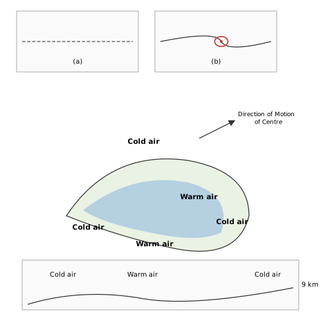
The diagram is built as a sequence of panels that walk you through the life story of an extra-tropical cyclone, from its birth as a kink on the polar front to its death as an occluded system. The top two small panels, (a) and (b), are plan views — you are looking down at the map. In (a) you see the front drawn as a dashed, curved line, still essentially a boundary between two air masses. In (b) that line has begun to bend, and a small circular symbol marks the developing low-pressure centre. This is the moment the textbook describes: pressure drops along the front, warm air pushes north, cold air surges south, and an anticlockwise cyclonic circulation is set in motion.
The next panel is a cross-section — a vertical slice through the atmosphere. Here the key visual is the wedge: cold air arrows converge from both sides, beneath a hatched wedge of warm air that sits above them. This is the fundamental geometry of a mid-latitude cyclone — warm air is lighter and rides up over the denser cold air, and the fronts are simply the sloping boundaries where that lifting happens.
Below that comes the most recognisable panel: the plan view of the fully developed, comma-shaped cyclone. You see curved bands of cold air and warm air spiralling around the centre, with the labels 'Cold air' appearing at three locations and 'Warm air' at two. This is the warm sector wedged between the forward warm front and the rear cold front. An arrow labelled 'Direction of Motion of Centre' shows the whole system moving — in reality, west to east. The comma shape itself is the visual signature of a mature extra-tropical cyclone, with the cold front sweeping around and beginning to catch up with the warm front.
The final panel, a cross-section labelled '9 km' in height, shows the end state: the fully occluded structure. Here the cold air bands are stacked and overtaking one another, and the warm air has been completely lifted off the surface. This is the occlusion the text describes — the cold front has caught the warm front, the warm sector is gone, and the cyclone is about to dissipate. …
The systems that develop in the mid and high latitudes, beyond the tropics, are called middle latitude or extra tropical cyclones. They are fundamentally different from the tropical cyclones that form near the equator, and they owe their existence to the interaction of contrasting air masses along a front.
The passage of a front causes abrupt changes in weather conditions over the area in the middle and high latitudes. Extra tropical cyclones form along the polar front, where cold polar air meets warmer subtropical air. Initially, the front is stationary. In the northern hemisphere, warm air blows from the south and cold air blows from the north of the front. When the pressure drops along the front, the warm air moves northwards and the cold air moves southwards, setting in motion an anticlockwise cyclonic circulation.
This cyclonic circulation leads to a well developed extra tropical cyclone, with a warm front and a cold front. There are pockets of warm air, or a warm sector, wedged between the forward and the rear cold air, or cold sector. The warm air glides over the cold air, and a sequence of clouds appears over the sky ahead of the warm front, causing precipitation. The cold front approaches the warm air from behind and pushes the warm air up. As a result, cumulus clouds develop along the cold front.
The cold front moves faster than the warm front and ultimately overtakes it. The warm air is completely lifted up, the front is occluded, and the cyclone dissipates. The processes of wind circulation both at the surface and aloft are closely interlinked throughout this life cycle.
The extra tropical cyclone differs from the tropical cyclone in several important ways:
- Extra tropical cyclones have a clear frontal system, which is not present in tropical cyclones. …
The systems developing in the mid and high latitude, beyond the tropics, are called the middle latitude or extra tropical cyclones. The passage of a front causes abrupt changes in the weather conditions over the area in the middle and high latitudes.
Extra tropical cyclones form along the polar front. Initially, the front is stationary. In the northern hemisphere, warm air blows from the south and cold air from the north of the front. When the pressure drops along the front, the warm air moves northwards and the cold air moves towards the south, setting in motion an anticlockwise cyclonic circulation. The cyclonic circulation leads to a well developed extra tropical cyclone, with a warm front and a cold front. There are pockets of warm air or warm sector wedged between the forward and the rear cold air or cold sector. The warm air glides over the cold air and a sequence of clouds appear over the sky ahead of the warm front and cause precipitation. The cold front approaches the warm air from behind and pushes the warm air up -- as a result, cumulus clouds develop along the cold front. The cold front moves faster than the warm front, ultimately overtaking the warm front; the warm air is completely lifted up and the front is occluded and the cyclone dissipates. …