Geography · Ch 15 — Atmospheric Circulation and Weather Systems
Fronts
Fronts
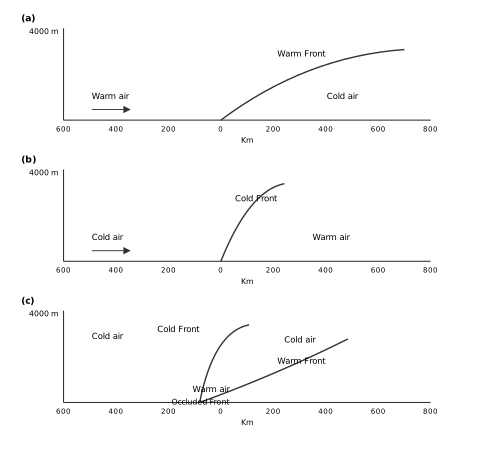
The diagram is a set of three vertical cross-sections, each slicing through the atmosphere from the ground up to a height of 4000 m. The horizontal axis is marked in kilometres, running from 600 km on one side of the front to 800 km on the other, with the front itself sitting near the centre at the 0 km mark. This layout lets you compare, side by side, how the slope of the boundary between two air masses differs depending on which air mass is doing the moving.
In the first panel, the warm front, a single curved line rises very gently from the ground and slopes upward to the right. The label "Warm Front" sits on this line. To the left of the boundary is warm air, with an arrow showing it moving toward the cold air on the right. The key visual point is the shallowness of the slope — warm air, being lighter, climbs over the cold air at a low angle, so the frontal surface extends far horizontally for every metre it rises vertically.
The second panel, the cold front, shows the opposite geometry. Here the boundary line is much steeper, rising sharply from the ground. Cold air occupies the left side, with an arrow showing it advancing toward the warm air on the right. Because cold air is denser, it undercuts the warm air and forces it upward abruptly, producing a steep frontal surface. The contrast in slope between the two panels is the entire lesson: warm fronts are gentle, cold fronts are steep.
The third panel, the occluded front, is the most complex. It shows two frontal lines — one labelled "Cold Front" and one labelled "Warm Front" — meeting at a single point above the ground. At their junction, the label "Occluded Front" marks the combined boundary. Below this junction, two separate regions of cold air exist: one beneath the warm air and one behind the advancing cold front. The warm air is shown lifted entirely off the ground, sandwiched between these two cold air masses. This is the defining feature of occlusion — the warm air mass has been completely raised above the surface, so the front at ground level is actually a boundary between two cold air masses, with the warm air riding aloft between them. …
When two different air masses meet, they do not mix readily. Instead, the boundary zone between them is called a front. The process by which fronts form is known as frontogenesis.
There are four types of fronts: cold, warm, stationary, and occluded.
- A stationary front is one that remains in place, with neither air mass advancing.
- A cold front forms when cold air moves towards a warm air mass. The contact zone is the cold front.
- A warm front forms when a warm air mass moves towards a cold air mass. The contact zone is the warm front.
- An occluded front occurs when an air mass is fully lifted above the land surface. …
When two different air masses meet, the boundary zone between them is called a front. The process of formation of the fronts is known as frontogenesis. There are four types of fronts: (a) Cold; (b) Warm; (c) Stationary; (d) Occluded. When the front remains stationary, it is called a stationary front. When the cold air moves towards the warm air mass, its contact zone is called the cold front, whereas if the warm air mass moves towards the cold air mass, the contact zone is a warm front. If an air mass is fully lifted above the land surface, it is called the occluded front. The fronts occur in middle latitudes and are characterised by steep gradient in temperature and p …