History · Ch 4 — Thinkers, Beliefs and Buildings — Cultural Developments
Stupas
Stupas
The idea of a sacred place did not begin with Buddhism. From very early times, people regarded certain natural sites as special — a grove of trees, an unusual rock formation, a spot of awe-inspiring beauty. Small shrines were often built at these places, and they were called chaityas. The word chaitya may itself come from chita, meaning a funeral pyre, and by extension a funerary mound. Buddhist literature mentions many such chaityas, showing that Buddhist ideas about sacred space grew out of a dialogue with existing traditions.
Why were stupas built?
The most sacred places for Buddhists were those associated with the Buddha's life: Lumbini (birth), Bodh Gaya (enlightenment), Sarnath (first sermon), and Kusinagara (death, or nibbana). About 200 years after the Buddha, Emperor Asoka erected a pillar at Lumbini to mark his visit.
But other places also became sacred because they contained relics of the Buddha — either his bodily remains or objects he had used. These relics were buried inside mounds called stupas. The tradition of building mounds may have been pre-Buddhist, but it became deeply associated with Buddhism. Because a stupa contained sacred relics, the entire structure came to be venerated as an emblem of the Buddha and of Buddhism itself.
According to the Ashokavadana (a Buddhist text), Asoka distributed portions of the Buddha's relics to every important town and ordered stupas to be built over them. By the second century BCE, a number of famous stupas had been constructed, including those at Bharhut, Sanchi, and Sarnath.
The Mahaparinibbana Sutta records that when the Buddha was asked what to do with his remains, he first told his disciple Ananda not to trouble themselves with honouring his remains. But when pressed, he said: "At the four crossroads they should erect a thupa (Pali for stupa) to the Tathagata. And whosoever shall there place garlands or perfume … or make a salutation there, or become in its presence calm of heart, that shall long be to them for a profit and joy."
How were stupas built?
Inscriptions found on the railings and pillars of stupas record donations made for their construction and decoration. These donations came from many kinds of people:
- Kings, such as the Satavahanas
- Guilds, such as the ivory workers who financed part of one of the gateways at Sanchi
- Hundreds of individual men and women, who often recorded their names, their home towns, their occupations, and the names of their relatives
- Bhikkhus and bhikkhunis (Buddhist monks and nuns) also contributed
The structure of the stupa
The word stupa means "a heap" in Sanskrit. It began as a simple, semi-circular mound of earth, later called the anda (meaning "egg"). Over time, it evolved into a more complex structure that balanced round and square shapes.
Key parts of a stupa, from bottom to top:
- Anda: The main semi-circular mound, originally of earth
- Harmika: A balcony-like structure above the anda, representing the abode of the gods
- Yashti: A mast rising from the harmika, often topped with a chhatri (umbrella)
- Railing: A stone railing that surrounded the mound, separating the sacred space from the secular world
- Gateways (toranas): Richly carved gateways installed at the four cardinal points (north, south, east, west) …
Chaitya. From earliest times people regarded certain places — with special trees, unique rocks or awe-inspiring natural beauty — as sacred; such sites, with small shrines attached, were sometimes called chaityas. The word may also derive from chita, a fu …
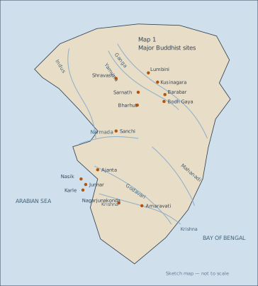
The map is a schematic, not-to-scale sketch of the Indian subcontinent, stretching from the Indus river system in the northwest to the Bay of Bengal in the east, and from the Himalayan foothills in the north down to the Krishna river in the south. Its purpose is to show the geographical spread of major Buddhist sites across the subcontinent, linking them to the river systems that often defined ancient trade routes and settlement patterns.
Seven rivers are drawn as reference lines: the Indus, the Ganga, the Yamuna, the Narmada, the Godavari, the Mahanadi, and the Krishna. Against these rivers, fourteen Buddhist sites are marked. In the north, along the Ganga plain, you see Shravasti, Lumbini (the Buddha's birthplace), Kusinagara (where he attained nibbana), and Sarnath (site of his first sermon). Bodh Gaya (where he attained enlightenment) lies near the confluence of the Ganga and Yamuna. Barabar is shown in the same region — these are the Barabar Caves, associated with early Buddhist (and Ajivika) rock-cut architecture.
Moving west, Sanchi and Bharhut are placed near the upper reaches of the Yamuna and the Narmada. These are the two most famous early stupa sites, with Sanchi's Great Stupa being the best-preserved example of the form described in the textbook. Further south, along the western coast near the Godavari, the map marks Nasik, Junnar, Karle, and Ajanta — all rock-cut cave complexes that flourished under the Satavahanas and later dynasties. On the eastern coast, near the Krishna river, are Amaravati and Nagarjunakonda, two major stupa and monastic sites of the Andhra region. …