History · Ch 2 — An Empire Across Three Continents
Late Antiquity
Late Antiquity
The period from the fourth to the seventh century marks a distinct phase in Roman history
Drawn by us to help you understand the concept clearly, and verified to make sure it's accurate. For exams, practice from your NCERT textbook's own diagram.
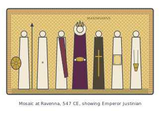
The mosaic is a formal, frontal composition carved in tiny glass and stone tesserae, set into the wall of the church of San Vitale in Ravenna, a city that served as the western capital of the Byzantine Empire. It dates to 547 CE, a moment when the emperor Justinian had recently reconquered much of the western Mediterranean, including Italy, from the Ostrogoths. The scene is not a narrative action but a ceremonial tableau: Justinian stands at the exact centre, flanked by two groups that together form a single, ordered procession moving toward the viewer’s left.
On the emperor’s right (the viewer’s left) are clergy, led by Bishop Maximianus, whose name appears in the mosaic’s own inscription — a rare and deliberate act of self-identification. Maximianus carries a cross, and he is the only figure besides Justinian whose name is recorded, signalling his political and ecclesiastical importance in Ravenna. On the emperor’s left are officials and soldiers, bearing a shield and other insignia of imperial authority. Justinian himself holds a paten, the shallow dish used in the Christian Eucharist, and wears a jewelled crown and a purple cloak — the colour reserved for the emperor alone. His halo, a golden disc behind his head, marks him not merely as a ruler but as a sacred figure, an image of Christ’s authority on earth.
The composition teaches a central idea of the early Byzantine state: the fusion of imperial and religious power. Justinian is shown as the head of both the secular administration and the Church, standing at the meeting point of clergy and army, court and altar. The mosaic does not depict a historical event — no specific ceremony is recorded — but rather an eternal statement of hierarchy. Every figure is shown frontally, with identical height and solemn expression, so that no individual personality intrudes; they are types, not portraits. The gold background, typical of Byzantine art, removes the scene from any earthly setting and places it in a timeless, heavenly space. …
, one that historians now call Late Antiquity. This era is no longer seen merely as a time of decline and fall
Drawn by us to help you understand the concept clearly, and verified to make sure it's accurate. For exams, practice from your NCERT textbook's own diagram.
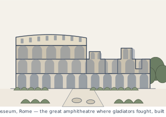
The figure shows the Colosseum at Rome, the great amphitheatre completed in 79 CE. It is presented as a cutaway or cross-section so you can see both the exterior tiers and the interior arena where the action happened. The caption tells you exactly what mattered to the Romans who built it: gladiators fought wild beasts there, and the whole thing was designed to hold a crowd of 60,000 people.
What the image teaches is scale and purpose. The Colosseum was not a temple or a public hall — it was a purpose-built arena for spectator blood sports, and its size tells you how central those games were to Roman urban life. Sixty thousand spectators is roughly the population of a decent-sized city in the ancient world, all packed into one building to watch combat. That number alone signals how much the emperors invested in public entertainment as a tool of control: keep the masses fed and amused, and they will not rebel.
The layout you see in the figure reflects that function. The outer walls rose in several storeys, each with arched openings, and inside, the seating sloped down in tiers toward the oval arena floor. Below the arena surface ran a network of chambers and passages — the hypogeum — where animals and gladiators were held before being hoisted up through trapdoors. The figure typically shows these underground levels cut open, so you can grasp that the spectacle was engineered from below, not just staged on the sand. …
, but as a period of profound transformation, where the classical Roman world gradually gave way to new political, social, and religious structures
Drawn by us to help you understand the concept clearly, and verified to make sure it's accurate. For exams, practice from your NCERT textbook's own diagram.
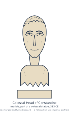
The figure shows a single, massive object: the marble head of the emperor Constantine, carved around 313 CE. It is not a complete statue but a fragment — the head alone, oversized and set apart from the body it once belonged to. The face is turned slightly upward, with a fixed, staring gaze that does not look at the viewer but past them, toward something distant. That upward tilt is deliberate; it gives the emperor a visionary, almost otherworldly quality, as if he is in direct communion with a higher power rather than with the people below.
What the image does not show is just as important as what it does. The head is part of a colossal enthroned statue, and the scale of that original work is the real subject of the figure. The head alone is enormous, which means the full statue would have towered over anyone who approached it. The caption tells us the date — 313 CE — which places it in the same year as the Edict of Milan, when Constantine legalised Christianity in the Roman Empire. The statue was not merely a portrait; it was a piece of imperial propaganda carved in stone. …
. It is within this stretch of time that the empire's centre of gravity shifted decisively eastward …
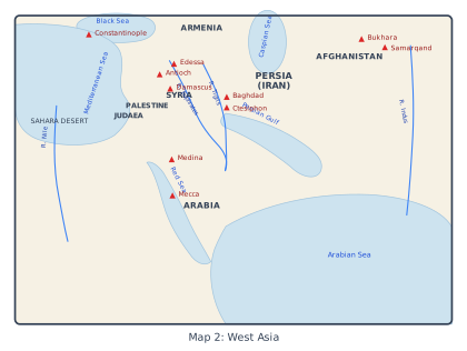
The map is a study in geography as destiny. It does not show a single empire, but a zone of contact — the land bridge where the Roman and Sasanian worlds met, overlapped, and fought. The eye is drawn first to the two great poles: the eastern Roman Mediterranean, anchored by Constantinople in the north and Antioch and Edessa further south, and the Sasanian heartland around Ctesiphon and Baghdad on the Tigris. These are not just cities; they are the twin capitals of two rival superpowers, and the space between them — the Fertile Crescent — is the contested frontier.
The map’s genius is that it refuses to stop at the political border. It pulls in the Caspian Sea to the north-east and the Black Sea to the north-west, framing the region as a closed arena. To the south, the Persian Gulf, Red Sea and Arabian Sea open the map to maritime routes, while the Sahara Desert presses down from the west like a wall. The rivers do the real work of explanation: the Tigris and Euphrates run through the Mesopotamian core, the Nile anchors Egypt on the far left, and the Indus appears on the far right — a reminder that this map is not just about Rome and Persia, but about the entire sweep of the ancient world from the Mediterranean to the Indian subcontinent.
The Arabian peninsula is given its own weight. Judaea, Palestine and Syria sit at the north-western edge, already under Roman influence, while Medina and Mecca appear deep in the interior — not yet the centres of a new faith, but already nodes in the caravan trade that linked the Red Sea to the Indian Ocean. The inclusion of Bukhara and Samarqand in the north-east, labelled under Afghanistan, is the map’s most revealing choice: these are Silk Road cities, far beyond Sasanian control, yet they appear because the map wants to show the whole network of routes, not just the empires that claimed them. …
The chapter closes with its own two-panel chronology of rulers and events across the empire, printed side by side.
RULERS
| Dates | Ruler |
|---|---|
| 27 BCE-14 CE | Augustus, first Roman emperor |
| 14-37 | Tiberius |
| 98-117 | Trajan |
| 117-38 | Hadrian |
| 193-211 | Septimius Severus |
| 241-72 | reign of Shapur I in Iran |
| 253-68 | Gallienus |
| 284-305 | the 'Tetrarchy'; Diocletian main ruler |
| 312-37 | Constantine |
| 309-79 | reign of Shapur II in Iran |
| 408-50 | Theodosius II (compiler of the famous 'Theodosian Code') |
| 490-518 | Anastasius |
| 527-65 | Justinian |
| 531-79 | reign of Khusro I in Iran |
| 610-41 | Heraclius |
EVENTS
| Date | Event |
|---|---|
| 27 BCE | 'Principate' founded by Octavian, now calls himself Augustus |
| c. 24-79 | Life of the Elder Pliny; dies in the volcanic eruption of Vesuvius, which also buries the Roman town of Pompeii |
| 66-70 | The great Jewish revolt and capture of Jerusalem by Roman forces |
| c. 115 | Greatest extent of the Roman Empire, following Trajan's conquests in the East |
| 212 | All free inhabitants of the empire transformed into Roman citizens |
| 224 | New dynasty founded in Iran, called 'Sasanians' after ancestor Sasan |
| 250s | Persians invade Roman territories west of the Euphrates |
| 258 | Cyprian bishop of Carthage executed |
| 260s | Gallienus reorganises the army |
| 273 | Caravan city of Palmyra destroyed by Romans |
| 297 | Diocletian reorganises empire into 100 provinces |
| c. 310 | Constantine issues new gold coinage (the 'solidus') |
| 312 | Constantine converts to Christianity |
| 324 | Constantine now sole ruler of empire; founds city of Constantinople |
| 354-430 | Life of Augustine, bishop of Hippo |
| 378 | Goths inflict crushing defeat on Roman armies at Adrianople |
| 391 | Destruction of the Serapeum (temple of Serapis) at Alexandria |
| 410 | Sack of Rome by the Visigoths |
| 428 | Vandals capture Africa |
| 434-53 | Empire of Attila the Hun |
| 493 | Ostrogoths establish kingdom in Italy |
| 533-50 | Recovery of Africa and Italy by Justinian |
| 541-70 | Outbreaks of bubonic plague |
| 568 | Lombards invade Italy |