History · Ch 2 — An Empire Across Three Continents
The Early Empire
The Early Empire
The Early Empire spans the first two and a half centuries of the Roman Principate, roughly from 27 BCE to 180 CE, a period often called the Pax Romana. During this time, the empire was ruled by a succession of emperors, beginning with Augustus, who established a system of personal rule while preserving the outward forms of the Republic. The section traces how this political framework held together a vast territory stretching from the Atlantic to the Euphrates
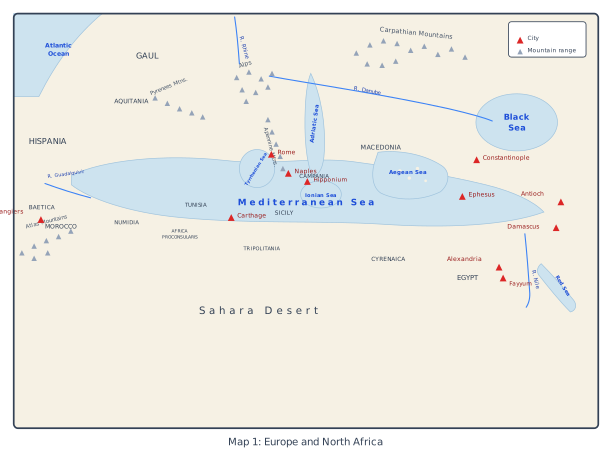
The map is a political and physical snapshot of the Roman Empire at its Mediterranean core, drawn to show how geography and imperial administration interlocked. Its western edge is the Atlantic Ocean, and the whole frame is anchored by the great inland sea that the Romans called Mare Nostrum — our sea. Every province, mountain range, and river on the map exists to explain one thing: how Rome ruled a landmass that wrapped entirely around the Mediterranean.
In the west, the map marks out Gaul (roughly modern France) and the Iberian peninsula as Hispania, with the southern province of Baetica singled out — a rich, heavily Romanised region known for olive oil and wine. The Alps rise as a natural barrier between Italy and the rest of Europe, and the map shows the rivers Rhine and Danube running along the northern frontier, with the Carpathian Mountains beyond them. These are not just labels; they are the empire's defensive skeleton. The Rhine and Danube were the lines where Roman legions were stationed, and the Carpathians mark the edge of the world Rome knew well.
Italy itself is drawn in detail. Rome sits at the centre, with Naples, Campania, and Hipponium (in the far south, on the toe of the boot) also named. The surrounding seas are all labelled — the Adriatic to the east, the Tyrrhenian to the west, the Ionian between Italy and Greece, and the Aegean beyond. Sicily appears as the large island at the toe of Italy, a crucial grain-producing province. The map's layout makes the point visually: Italy is the hub, and every sea route radiates from it.
Across the southern shore, the map traces the entire North African coast from west to east: Morocco, Numidia, Africa Proconsularis (the heartland of Roman Africa, around modern Tunisia), Tripolitania, Cyrenaica, and finally Egypt. The Atlas Mountains and the Sahara Desert are marked inland, showing how the fertile coastal strip was backed by an almost impassable barrier. Egypt is the prize — its Nile valley fed the empire's grain supply. The eastern cities complete the picture: Constantinople (the later capital), Ephesus, Antioch, Damascus, Alexandria, and Fayyum. These were not just towns; they were nodes of trade, administration, and culture, strung along the eastern Mediterranean like beads. …
, and how the emperors managed the army, the provinces, and the city of Rome itself …
'Then, after a winter (115/16) in Antioch marked by a great earthquake, in 116 Trajan marched down the Euphrates to Ctesiphon, the Parthian capital, and then to the head of the Persian Gulf. There [the historian] Cassius Dio describes him looking longingly at a merchant-ship setting off for India, and wishing that he were as yo …
'The famine prevalent for many successive years in many provinces has clearly displayed for men of any understanding the effect of malnutrition in generating illness. The city-dwellers, as it was their custom to collect and store enough grain for the whole of the next year immediately after the harvest, carried off all the wheat, barley, beans and lentils, and left to the peasants various kinds of pulse – after taking quite a large proportion of these to the city. After consuming what was left in the course of the winter, the country people had to resort to unhealthy foods in the spring; they ate twi …