History · Ch 1 — Writing and City Life
A Trading Town in a Pastoral Zone
A Trading Town in a Pastoral Zone
A trading town in a pastoral zone
Mari sits on the middle Euphrates, not far from the river’s bend where it swings close to the modern border with Syria. The map’s central feature is the river itself, drawn as a strong band running through the frame, with the city marked on its bank. Around it, the map distinguishes several zones of land, each shown with a different shading or symbol, and together they explain why this particular spot became a town at all.
The first zone is the river’s agricultural land — the strip of soil that the Euphrates waters directly, either through natural flooding or through canals cut from the river. This is the farmland that could support settled cultivation. Next to it, the map marks the land flooded each year for late-spring grazing. This is a subtler point: the flood did not merely water crops, it also refreshed pasture, and that pasture was available at a time of year when grazing elsewhere had dried up. The third zone is the plateau, higher ground beyond the reach of the river, and the fourth is the terraces canal water cannot reach — land that looks promising but is physically too high for irrigation, so it stays dry and largely unused. Finally, the map shows the seasonal streams, the wadis, which carry water only after rain and otherwise lie as dry channels cutting across the landscape. …
After 2000 BCE, the royal capital of Mari flourished. Unlike the southern plain with its highly productive agriculture, Mari stood much further upstream on the Euphrates. In this region, agriculture and animal rearing were carried out close to each other. Some communities in the kingdom of Mari had both farmers and pastoralists, but most of its territory was used for pasturing sheep and goats.
Herders needed to exchange young animals, cheese, leather and meat for grain, metal tools and other goods, and the manure of a penned flock was of great use to a farmer. Yet there could also be conflict. A shepherd might take his flock to water across a sown field, ruining the crop. Herdsmen, being mobile, could raid agricultural villages and seize their stored goods. Settled groups, for their part, might deny pastoralists access to river and canal water along certain paths.
Throughout Mesopotamian history, nomadic communities from the western desert filtered into the prosperous agricultural heartland. Shepherds would bring their flocks into the sown area in the summer. Such groups came in as herders, harvest labourers or hired soldiers, occasionally became prosperous, and settled down. A few gained the power to establish their own rule — these included the Akkadians, Amorites, Assyrians and Aramaeans.
The figure shows a single warrior, incised on a piece of shell around 2600 BCE. He stands holding a long spear in one hand and a wicker shield in the other. The wicker shield is the key visual clue: it is woven from reeds or cane, a light and flexible form of protection rather than a heavy metal or wooden one.
What makes this image significant is the warrior’s dress, which is typical of the Amorites, not of the Sumerians. The chapter earlier presents a Sumerian warrior, and comparing the two reveals a deliberate visual distinction between different peoples of ancient Mesopotamia. The Amorites were a Semitic people who lived on the fringes of the Sumerian city-states, and their appearance — as shown by this shell carving — was recognisably different from the urban Sumerians. …
The kings of Mari were Amorites. Their dress differed from that of the original inhabitants, and while they respected the gods of Mesopotamia, they also raised a temple at Mari for Dagan, the god of the steppe. Mesopotamian society and culture were thus open to different peoples and cultures, and the vitality of the civilisation was perhaps due to this intermixture.
The palace at Mari
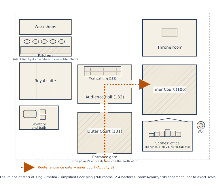
The great palace of Mari was the residence of the royal family, the hub of administration, and a place of production, especially of precious metal ornaments. It was so famous in its time that a minor king came from north Syria just to see it, carrying with him a letter of introduction from a royal friend of the king of Mari, Zimrilim. Daily lists reveal that huge quantities of food were presented each day for the king's table: flour, bread, meat, fish, fruit, beer and wine. He probably ate in the company of many others, in or around courtyard 106, paved white. You will notice from the plan that the palace had only one entrance, on the north. The large, open courtyards such as 131 were beautifully paved. The king would have received foreign dignitaries and his own people in 132, a room wit …
The great palace of Mari, built for King Zimrilim (1810–1760 BCE), was the residence of the royal family, the hub of administration, and a place of production, especially of precious metal ornaments. It was so famous in its time that a minor king came from north Syria just to see it, carrying a letter of introduction from a royal friend of the king of Mari.
Daily lists reveal that huge quantities of food were presented each day for the king's table: flour, bread, meat, fish, fruit, beer and wine. He probably ate in the company of many others, in or around courtyard 106, which was paved white. The palace had only one entrance, on the north. The large, open courtyards such as 131 were beautifully paved. The king would have received foreign dignitaries and his own people in room 132, a chamber with wall paintings that would have awed visitors. The palace was a sprawling structure with 260 rooms, covering an area of 2.4 hectares.
Drawn by us to help you understand the concept clearly, and verified to make sure it's accurate. For exams, practice from your NCERT textbook's own diagram.
The figure is a labelled plan, not an artist’s impression — it maps the ground layout of King Zimrilim’s palace at Mari, a major city on the middle Euphrates. The plan is organised around a sequence of courts and rooms, and the labels are what carry the historical argument.
At the heart of the plan is the throne room, the ceremonial core of the palace. It is reached through an audience hall (132), which in turn opens off the outer court (131). Beyond the outer court lies the inner court (106) — the more private, residential zone of the complex. The plan also marks the single entrance gate, a deliberate design choice: one controlled point of access, so that anyone entering the palace had to pass through a defined, defensible route. A well is shown within the palace precinct, a reminder that a royal household of this scale needed its own water supply rather than depending entirely on the river.
The most instructive part of the plan is the scribes’ office, drawn with its benches and clay bins for storing tablets. This is not a decorative detail — it is the physical evidence of administration. The palace was not just a residence; it was the centre of record-keeping, where grain deliveries, metal imports, and craft production were tracked on clay tablets. The benches show where scribes sat to write, and the bins show where finished tablets were stored. The plan thus makes visible the connection between urban power and written records. …
It included a scribes' office with benches and clay bins for storing tablets, a kitchen, workshops, a lavatory and bath, and a royal suite.
The kings of Mari, however, had to be vigilant. Herders of various tribes were allowed to move in the kingdom, but they were watched. The camps of herders are mentioned frequently in letters between kings and officials. In one letter, an officer writes to the king that he has been seeing frequent fire signals at night — sent from one camp to another — and he suspects that a raid or an attack is being planned.
Mari was located on the Euphrates in a prime position for trade — in wood, copper, tin, oil, wine and various other goods carried in boats along the river — between the south and the mineral-rich uplands of Turkey, Syria and Lebanon. It is a good example of an urban centre prospering on trade. Boats carrying grinding stones, wood, and jars of wine and oil would stop at Mari on their way to the southern cities. Officers of the town would go aboard, inspect the cargo — a single river boat could hold 300 wine jars — and levy a charge of about one-tenth the value of the goods before allowing the boat to continue downstream. Barley came in special grain boats. Most important, tablets refer to copper from 'Alashiya', the island of Cyprus, known for its copper, and tin was also an item of trade. Since bronze was the main industrial material for tools and weapons, this trade was of great importance. Thus, although the kingdom of Mari was not militarily strong, it was exceptionally prosperous.
Excavating Mesopotamian towns
Today, Mesopotamian excavators have much higher standards of accuracy and care in recording than in the old days, so that few dig huge areas the way Ur was excavated. Moreover, few archaeologists have the funds to employ large teams of excavators. Thus, the mode of obtaining data has changed.
Take the small town at Abu Salabikh, about 10 hectares in area in 2500 BCE with a population less than 10,000. The outlines of walls were at first traced by scraping surfaces. This involves scraping off the top few millimetres of the mound with the sharp and wide end of a shovel or other tool. While the soil underneath was still slightly moist, the archaeologist could make out different colours, textures and lines of brick walls or pits or other features. A few houses that were discovered were excavated. The archaeologists also sieved through tons of earth to recover plant and animal remains, and in the process identified many species of plants and animals and found large quantities of charred fish bones that had been swept out on to the streets. Plant seeds and fibre remained after dung cakes had been burned as fuel and thus kitchens were identified. Living rooms were those with fewer traces. Because they found the teeth of very young pigs on the streets, archaeologists concluded that pigs must have roamed freely here as in any other Mesopotamian town. In fact, one house burial contained some pig bones – the dead person …
Modern Mesopotamian excavators work to much higher standards of accuracy and care in recording than in the old days, so few dig huge areas the way Ur was excavated. Moreover, few archaeologists have the funds to employ large teams of excavators. The mode of obtaining data has therefore changed. …