History · Ch 1 — Writing and City Life
Mesopotamia and its Geography
Mesopotamia and its Geography
Iraq is a land of sharp contrasts, and those contrasts shaped where people could live, what they could grow, and eventually where the first cities rose. The geography of Mesopotamia is not a single uniform plain — it is a patchwork of mountains, steppe, desert, and river valleys, each offering a different kind of livelihood. Understanding this landscape is the first step to understanding why civilisation emerged where it did.
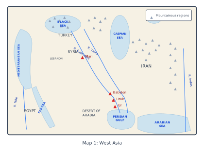
The map is a wide-angle view of West Asia, drawn to show where Mesopotamia sits in relation to the lands around it. It is not a map of Mesopotamia itself — that comes later in the chapter — but a stage-setting image. The region shown stretches from Turkey in the north-west, across Syria and Lebanon, down to Egypt in the south-west, and over to Iran in the east. The seas are all labelled: the Mediterranean to the west, the Black and Caspian Seas to the north, and the Arabian Sea to the south. These bodies of water frame the landmass and remind you that Mesopotamia was not an isolated pocket but part of a connected world.
The rivers are the heart of the map. The Euphrates and Tigris run through the middle, both rising in the northern mountains of Turkey and flowing south toward the Persian Gulf. The Nile is shown far to the west, cutting through Egypt, and the Indus appears to the east, in the region of modern Pakistan. Their presence on a single map is deliberate: it tells you that the great river-valley civilisations — Mesopotamia, Egypt and the Indus Valley — were roughly contemporary and geographically parallel, each built on the fertility that a major river brings to an otherwise dry land.
Four cities are marked: Mari, Babylon, Uruk and Ur. All lie along or near the Euphrates and Tigris, and all are Mesopotamian. Mari sits in the middle reaches of the Euphrates, Babylon further south, and Uruk and Ur in the far south, close to where the rivers approach the Gulf. These are not random dots — they are the very cities whose archives, temples and writing the chapter will examine. Seeing them on a map that also shows Turkey and Egypt makes the point that Mesopotamia's cities grew in a specific, southern desert zone, not across the whole region. …
The Four Zones of Mesopotamia
The region divides naturally into four distinct environmental zones, each with its own character and possibilities.
The north-east: green plains and mountains. Here lie undulating plains that gradually rise into tree-covered mountain ranges. These highlands have clear streams, wild flowers, and enough rainfall to support agriculture. It was here, between 7000 and 6000 BCE, that farming first began in the region.
The north: the steppe. A stretch of upland called a steppe runs across the north. Rainfall here is too low for reliable farming, so animal herding offers a better livelihood than agriculture. After the winter rains, sheep and goats feed on the grasses and low shrubs that grow on the steppe.
The east: routes into Iran. Tributaries of the Tigris river flow through the eastern region and provide routes of communication into the mountains of Iran. These river valleys were not just sources of water — they were corridors for movement and contact.
The south: desert — and the birthplace of cities. The south is a desert, and it is here that the first cities and writing emerged. This seems paradoxical: how could cities grow in a desert? The answer lies in the two great rivers.
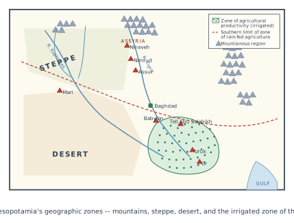
The map is a physical-geography map of Mesopotamia, not a political one. Its whole point is to show you why the first cities and writing appeared in the south, even though the south was desert. The caption tells you exactly what the map separates: mountains, steppe, desert, and the irrigated zone of the south.
The north-east corner is shown as green, undulating plains rising into tree-covered mountains — the rain-fed agricultural zone where farming began between 7000 and 6000 BCE. Moving west and south, the map marks a stretch of upland called the steppe, a zone too dry for reliable farming but good for herding sheep and goats after the winter rains. Below that, the map shows the desert — the vast southern region that gets almost no rainfall. The crucial thing the map does is mark the irrigated zone of the south as a distinct band within that desert, running along the rivers. That is the strip where the first cities and writing emerged.
The rivers are the backbone of the map: the Tigris and Euphrates, both rising in the northern mountains and flowing south-east into the desert, plus their tributaries the Balikh and Habur, which join the Euphrates from the north. The map shows how these rivers carry silt from the mountains and, once they enter the desert, break into small channels that flood their banks — channels that functioned as natural irrigation canals. That is the geographic logic the map is built around: the desert itself could not support farming, but the rivers made a narrow, intensely productive agricultural zone possible right through it. …
Why the Desert Could Support Cities
The Euphrates and the Tigris both rise in the northern mountains and flow south into the desert. As they travel, they carry loads of silt — fine mud. When the rivers flood, or when their water is deliberately let out onto the fields, this fertile silt is deposited on the land. The desert soil, enriched by silt, became capable of supporting dense settlement.
After the Euphrates enters the desert, its water flows out into small channels. These channels flood their banks and, in the past, functioned as irrigation canals. Water could be let into the fields of wheat, barley, peas, or lentils whenever necessary. This system of controlled flooding and irrigation was the foundation of southern Mesopotamia's productivity.
Southern Mesopotamia had insufficient rainfall to grow crops — its agriculture depended entirely on river water and irrigation. Yet, of all ancient agricultural systems, including that of the Roman Empire, it was the agriculture of southern Mesopotamia that was the most productive.