History · Ch 2 — Kings, Farmers and Towns — Early States and Economies
Administering the empire
Administering the empire
The empire was vast, stretching from Afghanistan to the eastern coast of India. But did it have a single, uniform administrative system? The evidence from Ashokan inscriptions suggests otherwise. The regions within the empire were simply too diverse — imagine the difference between the rugged hills of Afghanistan and the coastal plains of Odisha. Historians now believe that administrative control was strongest near the capital and the provincial centres, and weaker in the outlying areas.
The Five Major Political Centres
Ashokan inscriptions mention five key centres that formed the backbone of imperial administration:
- Pataliputra — the capital city.
- Taxila — a provincial centre in the northwest, situated on important long-distance trade routes.
- Ujjayini — a provincial centre in central India, also on key trade routes.
- Tosali — a provincial centre in the east (in present-day Odisha).
- Suvarnagiri — a provincial centre in the south, whose name literally means "the golden mountain." It was possibly important for tapping the gold mines of Karnataka.
These centres were not chosen at random. Taxila and Ujjayini, for instance, controlled major trade arteries. Suvarnagiri’s location hints at the economic importance of mineral wealth.
Languages and Scripts of the Inscriptions
The same message was engraved across the empire, but in different languages and scripts depending on the region:
| Region | Language | Script |
|---|---|---|
| Most of the subcontinent | Prakrit | Brahmi |
| Northwest of the subcontinent | Prakrit | Kharosthi |
| Northwest (Afghanistan area) | Aramaic and Greek | Aramaic and Greek scripts |
This diversity itself shows that the empire had to adapt to local conditions. A single administrative system would have been impractical.
Communication and the Army
The empire could not have survived without efficient communication. Journeys from the capital to the provinces could take weeks or even months. This required careful planning — arranging for provisions and protection for everyone on the move.
The army was essential for this protection. The Greek ambassador Megasthenes mentions a committee with six subcommittees to coordinate military activity:
- Navy
- Transport and provisions — this subcommittee had a wide range of duties: arranging bullock carts to carry equipment, procuring food for soldiers and fodder for animals, and recruiting servants and artisans to look after the soldiers.
- Foot-soldiers
- Horses
- Chariots
- Elephants
Ashoka’s Solution: Dhamma …
The lion capital is the polished sandstone sculpture that once crowned a pillar erected by Emperor Asoka at Sarnath, near Varanasi. It shows four lions seated back to back on a circular abacus, which itself rests on an inverted lotus. The abacus is carved with a frieze of four animals — an elephant, a galloping horse, a bull, and a lion — separated by chakras (dharma chakras). Today, this capital is the official national emblem of India.
The figure appears in the section discussing how Asoka administered his vast empire. The text explains that the empire had five major political centres: the capital Pataliputra and the provincial centres of Taxila, Ujjayini, Tosali, and Suvarnagiri. All these are mentioned in Asokan inscriptions. The lion capital is relevant here because it is one of the most famous surviving examples of Asokan pillar art — pillars that were erected across the empire, often bearing inscriptions of Asoka's dhamma.
The figure teaches that the lion capital is not just a decorative object but a symbol of imperial authority and communication. The pillar at Sarnath originally stood near the site of the Buddha's first sermon, linking Asoka's rule to Buddhist teachings. The four lions represent power and the spread of dhamma in all four directions. The chakras on the abacus reinforce the idea of righteous rule. The capital's polished sandstone finish shows the high level of craftsmanship supported by the Mauryan state. …
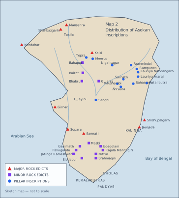
Map 2 in the NCERT textbook is a sketch map (not to scale) of the Indian subcontinent, showing the find-spots of Asokan inscriptions. It is divided into three categories: Major Rock Edicts, Minor Rock Edicts, and Pillar Inscriptions. The map also marks the region of Kalinga and the far-southern kingdoms of the Cholas, Keralaputras, and Pandyas, which lay beyond the Mauryan empire.
The Major Rock Edicts are found at Mansehra, Shahbazgarhi, Kandahar, Kalsi, Girnar, Sopara, Sannati, Shishupalgarh, and Jaugada. These are spread across the subcontinent — from the northwest (Mansehra, Shahbazgarhi, Kandahar) to the west (Girnar, Sopara), the east (Shishupalgarh, Jaugada in Kalinga), and the south (Sannati). The Minor Rock Edicts are concentrated in the south and central regions: Bahapur, Bairat, Bhabru, Gujarra, Maski, Gavimath, Palkigundu, Jatinga Rameshwar, Siddapur, Nittur, Brahmagiri, Udegolam, and Rajula Mandagiri. The Pillar Inscriptions are mostly in the north: Topra, Meerut, Nigalisagar, Rummindei, Rampurwa, Lauriya Nandangarh, Lauriya Araraj, Sarnath, Kaushambi, Ahraura, Sahasram, Sanchi, and Pataliputra.
The map shows that the same message was engraved across a vast area — from the North-West Frontier Provinces of Pakistan to Andhra Pradesh, Orissa, and Uttarakhand. Yet the distribution is uneven: Major Rock Edicts are found at the empire's edges, Pillar Inscriptions cluster in the Gangetic heartland, and Minor Rock Edicts are dense in the south. This pattern suggests that the empire did not have a uniform administrative system. The capital Pataliputra and provincial centres (Taxila, Ujjayini, Tosali, Suvarnagiri) are mentioned in the inscriptions, but the map implies that control was strongest near these centres and along trade routes. The inclusion of Kalinga (conquered in the Kalinga War) and the southern kingdoms (Cholas, Keralaputras, Pandyas) as labels beyond the empire's boundary reinforces that the Mauryan reach did not extend into the deep south.
The map's key uses three symbols (triangles, circles, squares) to distinguish the edict types, though the textbook reproduction uses labels. The sketch is not to scale — distances are approximate, and the relative positions of sites are schematic. …
Source 1 — What the king's officials did. Here is an excerpt from the account of Megasthenes, the Greek ambassador at the Mauryan court:
Of the great officers of state, some … superintend the rivers, measure the land, as is done in Egypt, and inspect the sluices by which water is let out from the main canals into their branches, so that every one may have an equal supply of it. The same persons have charge also of the huntsmen, and are entrusted with the power of rewarding or punishing them according to their deserts. They collect the taxes, and superintend the occupations connected with land; as those of the woodcutters, the carpenters, the blacksmiths, and the miners.
— Megasthenes, as preserved in later Greek accounts …