History · Ch 2 — Kings, Farmers and Towns — Early States and Economies
New cities
New cities
From roughly the sixth century BCE, a new wave of urban centres began to appear across the subcontinent. These were not isolated settlements — they were closely tied to the political and economic changes of the time. Many of these cities were the capitals of the mahajanapadas, the large kingdoms and republics that had emerged by this period.
Location was everything. Virtually all major towns were situated along important routes of communication. This was not accidental — being on a route meant access to trade, news, and resources. The routes themselves were of different kinds:
- Riverine routes: Some cities, like Pataliputra (modern Patna), were built on the banks of rivers. Rivers served as highways for the movement of goods and people, and also provided water and defence.
- Land routes: Other cities, such as Ujjayini (modern Ujjain), were positioned along overland trade routes that connected different parts of the subcontinent.
- Coastal routes: A third group, like Puhar (an ancient port town in Tamil Nadu), were located near the coast. From these ports, sea routes began, linking the subcontinent to distant lands across the ocean.
Some cities, however, were more than just transport hubs. Mathura, for instance, was a bustling centre where three kinds of activity converged: commerce (trade and markets), culture (art, religion, and learning), and politics (it was a seat of power for various rulers). Such cities became magnets for people, ideas, and goods, and their prosperity was built on this convergence. …
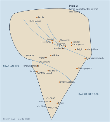
This is a sketch map of the Indian subcontinent, drawn not to scale, that shows the political and urban geography of the post-Mauryan period. The map is framed by the Arabian Sea on the west and the Bay of Bengal on the east, with the subcontinent's landmass filling the centre.
The map marks six major kingdoms that rose to prominence after the Mauryan empire declined. These are: the Kushanas in the northwest (centred around the region of Gandhara and the Punjab), the Shakas in the western and central parts (roughly modern Gujarat and Malwa), the Satavahanas in the Deccan (stretching from the western coast to the eastern Deccan), the Vakatakas in the central Deccan (north of the Satavahana territory), the Guptas in the middle Ganga valley (with their heartland around Prayag and Pataliputra), and the three southern kingdoms — the Cholas (in the Kaveri delta), the Cheras (on the Malabar coast), and the Pandyas (in the far south, around Madurai). These labels are placed roughly in their historical regions, showing the political fragmentation of the subcontinent after the Mauryas.
Scattered across the map are twenty towns and cities, each marked with a dot or label. These are: Taxila (in the northwest, a major gateway to Central Asia), Mathura (on the Yamuna, a key commercial and religious centre), Kanauj (on the Ganga, later a Gupta stronghold), Shravasti and Vaishali (both in the middle Ganga plain, ancient capitals of mahajanapadas), Varanasi (on the Ganga, a perennial urban centre), Kaushambi (near Allahabad, a major trade hub), Pataliputra (at the confluence of the Ganga and Son, the Mauryan capital), Rajgir (in the hills of Bihar, an early Magadhan capital), Mahasthan (in Bengal, an early historic site), Chandraketugarh (in the Ganga-Brahmaputra delta, a port town), Vidisha (in central India, near the Sanchi stupa), Ujjayini (on the Shipra river, a key inland trade centre), Bharukachchha (the ancient port of Broach on the Gujarat coast), Sopara (another port on the western coast, near modern Mumbai), Paithan (on the Godavari, the Satavahana capital), Dhanyakataka (on the Krishna, a major Satavahana centre), Shishupalgarh (in Odisha, a fortified early historic site), Kodumanal (in the Tamil region, an important bead-making and trade centre), and Puhar (the Chola port at the mouth of the Kaveri, from where sea routes began). …