History · Ch 1 — Bricks, Beads and Bones — The Harappan Civilisation
Beginnings
Beginnings
Concept First
The Harappan Civilisation did not appear suddenly. It grew out of a long sequence of earlier village-based farming and herding cultures that existed in the region well before the great cities were built. The urban, "Mature Harappan" phase was the outcome of a slow, internal process of change.
What the Evidence Shows
- Cultures before the cities: Several archaeological cultures existed in this region before the Mature Harappan phase. They are known through their own distinctive pottery styles, along with evidence of agriculture and animal-rearing (pastoralism), and some craft activity.
- Small, simple settlements: These early settlements were generally small. Archaeologists have found virtually no large buildings from this period — a sharp contrast with the planned cities of the later Mature Harappan phase.
- Farming roots around 7000 BCE: Recent archaeological evidence points to the roots of Harappan culture in early farming communities dating back to around 7000 BCE, well before the urban phase began.
- The Early Harappan phase: The formative stage that followed this early farming period, and led up to the Mature Harappan cities, is the phase historians label the Early Harappan phase.
Key Idea: Gradual Transformation, Not a Sudden Break
The textbook is explicit on this point: the urban Mature Harappan phase was "a consequent result of the gradual transformation and internal development of the civilisation during the early Harappan phase." City life did not appear out of nowhere — it was built on foundations laid over centuries by the communities that came before it. There is no single number or formula here — the key takeaway is this developmental sequence, from scattered early farming villages to a mature, city-based civilisation.
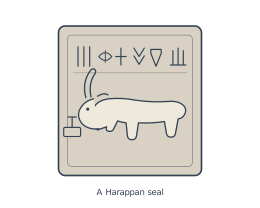
Drawn by us to help you understand the concept clearly, and verified to make sure it's accurate. For exams, practice from your NCERT textbook's own diagram.
This figure shows a steatite seal, one of the most iconic artefacts of the Harappan Civilisation. The seal is small and square, typical of the thousands found at Harappan sites.
What it depicts:
- Material: The seal is made of steatite, a soft stone that hardens when fired.
- Motif: At the centre is an animal motif — likely a unicorn-like bull or a humped bull, a common Harappan motif. The animal is shown in profile, with its head turned slightly.
- Script: Above the animal is a line of the Harappan script, which remains undeciphered to this day. This script is one of the great mysteries of the civilisation.
- Function: The seal was probably used for stamping — perhaps to mark ownership of goods or to authenticate documents. The animal motif and script together suggest a system of administration and trade.
What it teaches about the Harappan Civilisation:
- Craftsmanship: The carving is precise and detailed, showing advanced stone-working skills.
- Writing system: The presence of a script indicates a literate society, though we cannot yet read it.
- Economy: Seals like this were used in trade — they have been found in Mesopotamia, proving long-distance exchange.
- Standardisation: The square shape and consistent size suggest mass production and a standardised system of administration.
This single seal, though small, reveals much about Harappan urban life: organised trade, skilled crafts, and a complex system of communication and control.
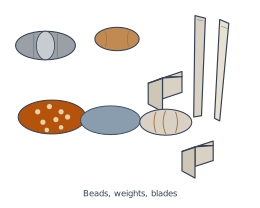
Drawn by us to help you understand the concept clearly, and verified to make sure it's accurate. For exams, practice from your NCERT textbook's own diagram.
This figure is a composite photograph, not a map or diagram. It shows a carefully arranged collection of three distinct types of small artefacts that archaeologists commonly find at Harappan sites.
What the figure shows, panel by panel:
-
Beads (likely top or left area): A cluster of finished beads made from different materials — carnelian (red), steatite (soft white stone), and possibly faience (a glazed material). Some are long and barrel-shaped, others short and cylindrical. These were used for personal ornamentation and were also traded.
-
Cubical chert weights (central area): Small, precisely cut cubes of chert (a hard, fine-grained stone). They are of graduated sizes, indicating a standardised system of weighing. These were essential for trade — to measure commodities like grain, metal, or beads.
-
Stone blades (likely bottom or right area): Long, thin, sharp-edged blades made from chert or other siliceous stone. They were mass-produced using a technique called "crested guiding ridge" and were used as everyday cutting tools — for harvesting, butchering, or craft work.
What the figure teaches about the Harappan Civilisation:
- Craft specialisation: The presence of beads, weights, and blades together in one image shows that Harappan society had distinct craft groups — bead-makers, stone-tool knappers, and traders who used standard weights.
- Trade and economy: The cubical chert weights are evidence of a standardised system of exchange. This implies organised trade, both within the civilisation and with distant regions (e.g., carnelian from Gujarat, chert from the Rohri hills).
- Everyday life and technology: The stone blades represent practical, everyday tools. Their uniformity suggests mass production and a high level of skill in stone working.
- Archaeological evidence: The figure is a visual summary of the kinds of small finds that help archaeologists reconstruct Harappan economy, technology, and social organisation — without relying on large buildings or inscriptions.
In short, this figure is not just a random assortment — it is a curated sample of the material culture that defines the Mature Harappan phase: objects of ornamentation (beads), measurement (weights), and utility (blades).
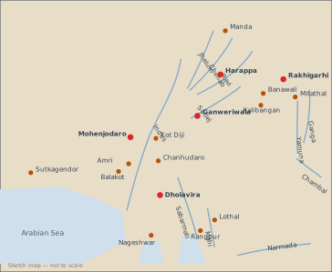
What Map 1 Shows
The map is a sketch map (not to scale) of the north-western part of the Indian subcontinent. It focuses on the region where the Mature Harappan civilisation flourished. The map does not show modern political boundaries; instead, it highlights the river systems and the Arabian Sea as the natural backdrop.
River systems marked:
- The Indus and its five major tributaries: Jhelum, Chenab, Ravi, and Sutlej.
- The Ganga and Yamuna in the east.
- The Chambal, Sabarmati, Mahi, and Narmada in the south and west.
Sites marked (all Mature Harappan):
- Northernmost: Manda (on the upper reaches of the Indus system).
- Along the Indus and its tributaries: Harappa, Banawali, Rakhigarhi, Mitathal, Ganweriwala, Kot Diji, Chanhudaro, Amri, Balakot, Mohenjodaro.
- Westernmost: Sutkagendor (near the Arabian Sea coast).
- Southern and eastern: Dholavira, Lothal, Nageshwar, Rangpur (in Gujarat and along the coast), and Kalibangan (on the Ghaggar-Hakra river, now dry).
What It Teaches About the Topic
The map visually reinforces the geographical spread of the Mature Harappan civilisation. It shows that the civilisation was not confined to the Indus valley alone — sites extend into present-day Gujarat (Lothal, Dholavira), Rajasthan (Kalibangan), Haryana (Rakhigarhi, Banawali), and even up to the Himalayan foothills (Manda). This wide distribution — from Sutkagendor in the west to Rangpur in the east, and from Manda in the north to Dholavira in the south — indicates a vast, interconnected cultural zone.
The map also highlights the importance of river systems for settlement. Almost all sites are located near rivers or the coast, showing that water, trade routes, and fertile floodplains were central to Harappan urban life. The absence of large buildings in earlier cultures (as mentioned in the textbook text) contrasts with the urban planning implied by the many large sites on this map — a key feature of the Mature Harappan phase.
Finally, the map helps students understand that the Mature Harappan phase was not an isolated event but the culmination of a long process — from early farming communities (c. 7000 BCE) to the urban centres shown here. The sites are not randomly placed; they reflect a deliberate choice of location for agriculture, trade, and defence.