History · Ch 2 — Kings, Farmers and Towns — Early States and Economies
The sixteen mahajanapadas
The sixteen mahajanapadas
The sixth century BCE marks a major turning point in early Indian history. This period saw the rise of early states, cities, the growing use of iron, and the development of coinage. It was also a time of great intellectual ferment, with the growth of Buddhism and Jainism.
Early Buddhist and Jaina texts mention sixteen states known as the mahajanapadas. While the lists vary, certain names appear frequently: Vajji, Magadha, Koshala, Kuru, Panchala, Gandhara, and Avanti. These were clearly among the most important.
Types of rule
Most mahajanapadas were ruled by kings. However, some were ganas or sanghas — oligarchies where power was shared by a number of men, often collectively called rajas. Both Mahavira and the Buddha belonged to such ganas. In the Vajji sangha, for instance, the rajas probably controlled resources like land collectively.
Oligarchy means a form of government where power is exercised by a group of men. The Roman Republic, despite its name, was an oligarchy.
Features of the mahajanapadas
- Each mahajanapada had a capital city, which was often fortified.
- Maintaining these fortified cities, as well as providing for armies and bureaucracies, required substantial resources.
- From around the sixth century BCE, Brahmanas began composing Sanskrit texts called the Dharmasutras. These laid down norms for rulers, who were ideally expected to be Kshatriyas.
- Rulers were advised to collect taxes and tribute from cultivators, traders, and artisans. It is unclear whether resources were also procured from pastoralists and forest peoples.
- Raids on neighbouring states were recognised as a legitimate means of acquiring wealth.
- Gradually, some states acquired standing armies and maintained regular bureaucracies. Others continued to depend on militia recruited mostly from the peasantry.
Challenges for historians
The histories of these states are often difficult to reconstruct due to the lack of sources. Despite this, some of these states lasted for nearly a thousand years.
Understanding the term janapada
Janapada means the land where a jana (a people, clan, or tribe) sets its foot or settles. It is a word used in both Prakrit and Sanskrit.
Inscriptions as sources
Inscriptions are writings engraved on hard surfaces such as stone, metal, or pottery. They usually record the achievements, activities, or ideas of those who commissioned them — including the exploits of kings, or donations made by women and men to religious institutions.
- Inscriptions are virtually permanent records. Some carry dates; others are dated on the basis of palaeography (styles of writing) with fair precision. …
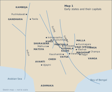
Map 1 is a schematic, not-to-scale sketch of the northern part of the Indian subcontinent, stretching from the Arabian Sea in the west to the Bay of Bengal in the east. Its purpose is to show the location of the sixteen mahajanapadas — the major states of the sixth century BCE — and their respective capital cities.
The map is divided into two main geographical zones by a faint line that roughly follows the course of the Ganga and Yamuna rivers. The western half contains the mahajanapadas of KAMBOJA, GANDHARA, KURU, PANCHALA, MATSYA, SHURASENA, CHEDI, VATSA, and AVANTI. Their capitals are marked as dots: Taxila and Pushkalavati for Gandhara and Kamboja (in the far north-west, near the Indus), Indraprastha for Kuru, Ahichchhatra for Panchala, Mathura for Shurasena, Kaushambi for Vatsa, and Ujjayini for Avanti. The eastern half holds KOSHALA, MALLA, KASHI, VAJJI (also labelled VRIJJI), MAGADHA, ANGA, VANGA, and ASHMAKA. Their capitals are Shravasti (Koshala), Kusinagara (Malla), Varanasi (Kashi), Vaishali (Vajji), Rajgir (Magadha), Champa (Anga), and — though not explicitly listed in the description — the capital of Vanga is not named, and Ashmaka’s capital is also absent from the provided list.
The map also shows the two major water bodies: the Arabian Sea on the left and the Bay of Bengal on the right, with the subcontinent’s coastline sketched in. No rivers, mountains, or modern political boundaries are marked — the map is deliberately simplified to focus on the political geography of the period.
The map is a teaching tool, not a precise geographical survey. It groups the mahajanapadas into two clusters: the western group (centred on the upper Ganga-Yamuna doab and the north-west) and the eastern group (centred on the middle Ganga plain and the eastern coast). This division reflects the actual historical concentration of early states in these two regions. …